Mamucium
- Mamucium
-

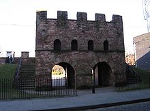
Porte reconstituée du fort romain.
Mamucium, également connue sous le nom de Mancunium, était un fort romain de la province de Britannia[1]. Les restes du fort, situés dans le quartier de Castlefield à Manchester, dans le nord-ouest de l'Angleterre, sont protégés comme Scheduled Ancient Monument[2]. Fondé en 79, Mamucium était gardé par une garnison de soldats qui veillaient sur la route reliant Chester à York. Un vicus, ou peuplement civil regroupant des marchands et la famille des soldats, se développa en dehors du fort et devint une zone de forte activité économique.
Le site demeura en ruines jusqu'à la révolution industrielle. À cette période, la ville de Manchester s'étend et le fort est fini de détruire pour faire place à de nouvelles constructions. Il est abîmé par la construction du Rochdale Canal et du Great Northern Railway. Des parties du fort ont aujourd'hui été restaurées et sont visibles pour le public.
Références
- ↑ A L F Rivet et Colin Smith, The Place-Names of Roman Britain, Londres, B T Batsford, 1979
- ↑ Mamucium, Pastscape.org.uk. Consulté le 29 décembre 2007
Wikimedia Foundation.
2010.
Contenu soumis à la licence CC-BY-SA. Source : Article Mamucium de Wikipédia en français (auteurs)
Regardez d'autres dictionnaires:
Mamucium — Mamucium … Wikipedia
Castlefield — Or see Castlefields. infobox UK place static static image caption=View of Castlefield in 2007 country = England official name= Castlefield latitude= 53.475 longitude= 2.255 population= metropolitan borough= City of Manchester metropolitan county … Wikipedia
History of Manchester — The history of Manchester is one of change from a minor Lancastrian township into the pre eminent industrial metropolis of the United Kingdom and the world. Manchester began expanding at an astonishing rate around the turn of the 19th century as… … Wikipedia
Manchester — This article is about the city of Manchester in England. For the wider metropolitan county, see Greater Manchester. For the larger conurbation, see Greater Manchester Urban Area. For other uses, see Manchester (disambiguation). Coordinates … Wikipedia
Manchester — Manchester … Wikipédia en Français
Roman Britain — History of the British Isles This box: view · talk · edit … Wikipedia
Blackburn — For other uses, see Blackburn (disambiguation). Coordinates: 53°44′42″N 2°28′37″W / 53.7449°N 2.4769°W / 53.7449; 2.4769 … Wikipedia
Affetside — infobox UK place country = England latitude = 53.618 longitude = 2.368 official name= Affetside population= metropolitan borough= Bury metropolitan county= Greater Manchester region = North West England constituency westminster= Bury North post… … Wikipedia
Castleshaw Roman fort — Infobox Historic building caption=A ditch of Castleshaw Roman fort name=Castleshaw Roman fort location town=Castleshaw Saddleworth Greater Manchester location country=England map type=Greater Manchester latitude=53.583245 longitude= 2.001737… … Wikipedia
Kersal Moor — Infobox Mountain Name = Kersal Moor Photo = Kersal Moor.jpg Caption = Kersal Moor, August 2007 Elevation = convert|30|ft|m|1 to convert|75|ft|m|1 Location = Kersal, Greater Manchester, England Range = Prominence = Coordinates =… … Wikipedia

