Malmsbury
- Malmsbury
-
Malmsbury (587 habitants) est un petit village à 96 km au nord de Melbourne, dans l'État de Victoria, en Australie sur l'ancienne Calder Highway près de la Coliban River.
Liens externes
Sur les autres projets Wikimedia :
Wikimedia Foundation.
2010.
Contenu soumis à la licence CC-BY-SA. Source : Article Malmsbury de Wikipédia en français (auteurs)
Regardez d'autres dictionnaires:
Malmsbury, Victoria — Malmsbury Victoria The Calder Highway at Malmsbury … Wikipedia
Malmsbury railway station — Malmsbury Station information Code MMY Distance from Southern Cross 104.16 km (64.72 mi) Operator V/Line … Wikipedia
Malmsbury railway station, Victoria — VlineRailwayStation1 NAME=Malmsbury CODE=MMY DISTANCE=km to mi|104.16|abbr=yes LINES=Bendigo PLATFORMS=2 TRACKS=1 STATUS=Unmanned Station FACILITIES= [http://www.viclink.com.au/stop/view/20326 Link] TIMETABLES=… … Wikipedia
Calder Freeway — Infobox Australian Road | type=freeway road name = Calder Freeway route route route photo = CalderFreeway.jpg caption = Calder Freeway facing Mt. Macedon Formerly length = 94 direction = Northwest Southeast start = finish = est = through =… … Wikipedia
Coliban River — Die Trentham Falls am Oberlauf des Coliban RiverVorlage:Infobox Fluss/KARTE fehlt … Deutsch Wikipedia
Midland Highway (Victoria) — This article is about the highway in Victoria, Australia. For the highway in Tasmania, Australia, see Midland Highway (Tasmania). Midland Highway … Wikipedia
Reginald Sturgess — Reginald Ward Sturgess (18 June 1892 ndash; 2 July 1932) was an Australian artist.Sturgess was born in 1892 in the Melbourne suburb of Newport, Victoria, the son of cabinet maker Edward Sturgess and his wife Emma (née Ward), migrants from Bath,… … Wikipedia
Shire of Kyneton — Infobox Australian Place | type = lga name = Shire of Kyneton state = vic region = area = 725.2 est = 1859 seat = Kyneton pop = 8920 (1992) [cite book|title=Victorian Year Book|author=Australian Bureau of Statistics, Victoria… … Wikipedia
Coliban River — Trentham Falls in the upper stretches of the River Origin Great Dividing Range Mouth Lake Eppalock … Wikipedia
DAVY, Edward (1806-1885) — one of the inventors of the electric telegraph was the son of Thomas Davy, a surgeon. He was born at Ottery, St Mary, Devonshire, on 6 June 1806, and was educated at a school kept by his maternal uncle, a Mr Boutflower, in London. When about 16… … Dictionary of Australian Biography
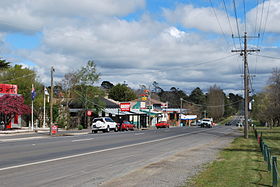 La grand'rue de Malmsbury
 Australie

