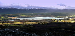
Loch Insh
- Loch Insh
-
Le loch Insh est un loch dans la région de Highlands, en Écosse.
Il est situé au cœur de la région de Badenoch et Strathspey, à 11 km au sud de Aviemore et à 11 km au nord de Kingussie. Le loch est un emplacement pour la voile et le Canoë-kayak. Au sud-est du lac se trouve un centre de sports nautiques. Notons également que ses eaux sont poissonneuses. Le centre de sports nautiques est agrémenté par plusieurs chalets et un petit hôtel nommé "Insh Hall".
Liens internes
Liens externes
Wikimedia Foundation.
2010.
Contenu soumis à la licence CC-BY-SA. Source : Article Loch Insh de Wikipédia en français (auteurs)
Regardez d'autres dictionnaires:
Loch Insh — mit der Insel Tom Dubh Geographische Lage Highland, Schottland Zuflüsse Spey … Deutsch Wikipedia
Loch Insh — Infobox lake lake name = Loch Insh image lake = caption lake = image bathymetry = caption bathymetry = location = Highlands, Scotland coords = coord|57|07|N|3|55|W|region:GB type:waterbody source:GNS enwiki|display=inline,title type = freshwater… … Wikipedia
HMS Loch Insh (K433) — was a Loch class frigate of the Royal Navy. She was built by Henry Robb of Leith and launched on 10 May 1943. She was named after Loch Insh in Scotland.She served in World War II. On 29 April 1945, in the Barents Sea she assisted Anguilla and… … Wikipedia
Insh — INSH, lately a quoad sacra parish, formed of part of the parish of Kingussie, and a small part of that of Alvie, in the county of Inverness; containing 613 inhabitants, of whom 88 are in the village of Insh, 7 miles (N. E.) from Pitmain. This… … A Topographical dictionary of Scotland
Loch class frigate — The Loch class was a class of anti submarine (A/S) frigate built for the Royal Navy and her allies during World War II. They were an innovative design based on the experience of 3 years of fighting in the Battle of the Atlantic and attendant… … Wikipedia
Pantanos de Insh — Saltar a navegación, búsqueda Los Pantanos de Insh (en inglés, Insh Marshes) son 10 kilómtros cuadrados de planicie aluvial del río Spey entre Kingussie y Kincraig en Badenoch and Strathspey, Highland, Escocia (Reino Unido). Quedan a ambos lados… … Wikipedia Español
Highland Railway Loch Class — Infobox Locomotive name = Highland Railway Loch class powertype = Steam caption = designer = David Jones builder = flagicon|Scotland Dübs Co. (15)flagicon|Scotland North British Loco (3) whytetype = 4 4 0 gauge = RailGauge|ussg builddate = 1896… … Wikipedia
Liste schottischer Lochs — Loch ist das schottisch gälische Wort für einen See oder eine Meeresbucht, einen Fjord (englisch Firth). Das Wort, lɔx, «loch» mit kehligem «ch» ausgesprochen, ist verwandt mit dem altirischen Lough, rekonstruierte indogermanische Wurzel… … Deutsch Wikipedia
Battle of Dun Nechtain — Part of the Pictish Northumbrian conflicts … Wikipedia
Kingussie — KINGUSSIE, a parish, in the Mainland district of the county of Inverness, ½ a mile (E. by N.) from Pitmain; containing, with part of the late quoad sacra parish of Insh, the villages of Kingussie and Newtonmore, and the hamlet of Ralia, 2047… … A Topographical dictionary of Scotland
 Royaume-Uni
 Écosse)
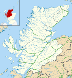


 Portail du monde maritime
 Portail de l’Écosse

