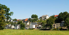
Langenwetzendorf
Contenu soumis à la licence CC-BY-SA. Source : Article Langenwetzendorf de Wikipédia en français (auteurs)
Regardez d'autres dictionnaires:
Langenwetzendorf — Langenwetzendorf, Dorf an der Leuba in Reuß Schleiz; viel Zeug u. Leinweber; 1800 Ew … Pierer's Universal-Lexikon
Langenwetzendorf — Langenwetzendorf, Dorf im Fürstentum Reuß s. L., Unterländischer Bezirk, 348 m ü. M., hat eine evang. Kirche, Weberei, Bierbrauerei und (1900) 2236 Einw … Meyers Großes Konversations-Lexikon
Langenwetzendorf — Wappen Deutschlandkarte … Deutsch Wikipedia
Langenwetzendorf — Infobox Ort in Deutschland image photo = Wappen = Wappen Langenwetzendorf.png lat deg = 50 |lat min = 40 |lat sec = 37 lon deg = 12 |lon min = 5 |lon sec = 53 Lageplan = Langenwetzendorf in GRZ.png Bundesland = Thüringen Landkreis = Greiz Höhe =… … Wikipedia
Langenwetzendorf — Original name in latin Langenwetzendorf Name in other language Langenwetzendorf State code DE Continent/City Europe/Berlin longitude 50.68333 latitude 12.11667 altitude 416 Population 3774 Date 2011 04 25 … Cities with a population over 1000 database
Liste der Orte im Landkreis Greiz — Diese Liste enthält alle Orte (Städte, Gemeinden und Ortsteile) im thüringischen Landkreis Greiz. Ort Gemeinde Einwohner (ca.) Albersdorf Berga 150 Altgernsdorf Wildetaube 100 Arnsgrün Vogtländisches Oberland 270 Auma, Stadt Auma … Deutsch Wikipedia
Bernsgrün — Wappen Deutschlandkarte Hilfe zu Wappen … Deutsch Wikipedia
Kuhdorf — Wappen Deutschlandkarte Hilfe zu Wappen … Deutsch Wikipedia
Neumühle (Elster) — Wappen Deutschlandkarte … Deutsch Wikipedia
Zeulenroda — Wappen Deutschlandkarte … Deutsch Wikipedia

 Allemagne
 Thuringe


