Kožuchovce
- Kožuchovce
-
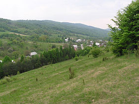
Kožuchovce est un village de Slovaquie situé dans la région de Prešov.
Histoire
Première mention écrite du village en 1618. En 1927, l'église en bois du village est déplacée à Košice.
Notes et références
Catégories :
- Village de Slovaquie
- Village et ville du district de Stropkov
Wikimedia Foundation.
2010.
Contenu soumis à la licence CC-BY-SA. Source : Article Kožuchovce de Wikipédia en français (auteurs)
Regardez d'autres dictionnaires:
Kožuchovce — Geobox | Settlement name = Kožuchovce other name = category = Village image caption = symbol = etymology = official name = motto = nickname = country = Slovakia country state = region = Prešov district = Stropkov commune = municipality = part =… … Wikipedia
Stropkov District — District Country Slovakia Region … Wikipedia
Okres Stropkov — Übersichtskarten Basisdaten Okres Stropkov … Deutsch Wikipedia
Stropkov (Okres) — Übersichtskarten Basisdaten Okres/Bezirk Stropkov … Deutsch Wikipedia
East Slovak Museum — The East Slovak Museum ( sk. Východoslovenské múzeum) in Košice, Slovakia, is one of the oldest Slovak museums; it was founded in 1872.A neo Renaissance building was erected in the early 20th century. It was the first building in the town… … Wikipedia
Makovce — Coordinates: 49°16′N 21°45′E / 49.267°N 21.75°E / 49.267; 21.75 … Wikipedia
Chotča — Location of Stropkov District in the Prešov Region. Chotča is a village and municipality in Stropkov District in the Prešov Region of north eastern Slovakia. History In historical records the village … Wikipedia
Duplín — Location of Stropkov District in the Prešov Region. Duplín is a village and municipality in Stropkov District in the Prešov Region of north eastern Slovakia. History In historical records the village … Wikipedia
Malá Poľana — Location of Stropkov District in the Prešov Region. Malá Poľana is a village and municipality in Stropkov District in the Prešov Region of north eastern Slovakia. History In historical records the villa … Wikipedia
Miková — Location of Stropkov District in the Prešov Region. Miková or Mikó (település) in Hungarian, is a village and municipality in the former Eperjes County (http://hu.wikipedia.org/wiki/Eperjesi ker%C3%BClet) of the Kingdom of Hungary. The area was… … Wikipedia
 Slovaquie
 Kožuchovce


