Hunga Tonga
- Hunga Tonga
-
Hunga Tonga est un volcan sous-marin des Tonga.
Géographie
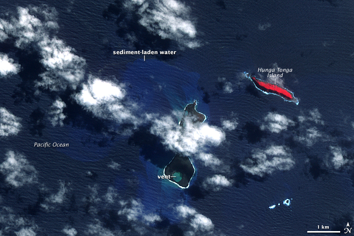
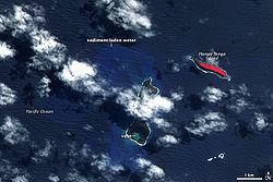
Hunga Tonga est situé à trente kilomètres au sud-sud-est de Fonuafo'ou. Le volcan fait partie de l'arc volcanique Tonga-Kermadec.
Le volcan lui-même est un volcan sous-marin ; les deux îles de Hunga Tonga et Hunga Ha'apai sont les parties émergées de son cratère. Il est entré en éruption en 2009[2].
Annexes
Articles connexes
Lien externe
Références
Wikimedia Foundation.
2010.
Contenu soumis à la licence CC-BY-SA. Source : Article Hunga Tonga de Wikipédia en français (auteurs)
Regardez d'autres dictionnaires:
Tonga — Este artículo trata sobre el país insular del Pacífico. Para el pueblo en Nanumanga (Tuvalu), véase Tonga (Tuvalu). Pule anga Fakatu i o Tonga Kingdom of Tonga Reino de Tonga … Wikipedia Español
List of cities in Tonga — The following list gives all islands and cities (villages and hamlets) in Tonga in alphabetical order with many local areas and (poetical) nicknames as well.Layout(An overview of the adopted layout method for each archipelago main group.… … Wikipedia
Liste des volcans des Tonga — Cet article recense les volcans des Tonga. Sommaire 1 Liste 2 Annexes 2.1 Liens internes 2.2 Liens externes … Wikipédia en Français
Liste von Vulkanen in Tonga — Karte mit allen Koordinaten: OSM, Google oder … Deutsch Wikipedia
Terremoto de Tonga de 2009 — Localización del epicentro en el océano Pacífico … Wikipedia Español
Cabinet of Tonga — Tonga This article is part of the series: Politics and government of Tonga Constitution King Geo … Wikipedia
2006 Tonga earthquake — The 2006 Tonga earthquake occurred on 4 May 2006 at 04:26 local time (3 May 2006 at 15:26 UTC). There were no reports of death or injury. With a strength of 7.9 it was the strongest quake since the 28 March 2005 Sumatra earthquake following from… … Wikipedia
Organización territorial de Tonga — Mapa de Tonga. Aunque geográficamente está compuesto por 169 islas (36 de ellas deshabitadas) el Reino de Tonga las divide políticamente en tres grupos de islas: Grupo Tongatapu: Eua Ata Tongatapu Arrecifes Minerva Grupo Ha apai: Kao … Wikipedia Español
Kae and Longopoa — The story cycle around Kae and Sinilau is a well known entity in Polynesian mythology, found back on several places (see notes). This article describes the Tongan version, of which the main source is an old poem (Ko e folau ʻa Kae – The voyage of … Wikipedia
New islands — are islands which have been created recently, whether by means of vulcanism, erosion, glacial retreat, or other mechanisms. One of the most famous new volcanic islands is the small island of Surtsey, located in the Atlantic Ocean south of Iceland … Wikipedia
 Tonga
Tonga