Drayton (Vale of White Horse)
- Drayton (Vale of White Horse)
-
51° 38′ 49″ N 1° 18′ 47″ W / 51.647, -1.313
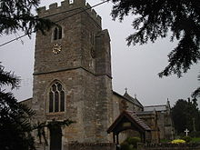
L'église Saint-Pierre de Drayton
Drayton est un village et une paroisse civile située à 3,2 kilomètres au sud d'Abingdon, dans le district Vale of White Horse de l'Oxfordshire (appelé Berkshire jusqu'en 1974). Sa population est de 2400 habitants.
Le village conserve une église du XIIe siècle, construite dans le style normand. Son clocher, ajouté ultérieurement, s'inspire du gothique perpendiculaire. Le chœur fut reconstruit en 1872 et l'architecte Edwin Dolby restaura l'église et le porche sud dans le goût néo-gothique en 1879.
Drayton est jumelée depuis l'an 2000 à la ville française de Lesparre-Médoc, dans le département de la Gironde et la région Aquitaine.
Notes et références
Wikimedia Foundation.
2010.
Contenu soumis à la licence CC-BY-SA. Source : Article Drayton (Vale of White Horse) de Wikipédia en français (auteurs)
Regardez d'autres dictionnaires:
Drayton, Vale of White Horse — Coordinates: 51°38′49″N 1°18′47″W / 51.647°N 1.313°W / 51.647; 1.313 … Wikipedia
Milton, Vale of White Horse — Coordinates: 51°37′37″N 1°17′53″W / 51.627°N 1.298°W / 51.627; 1.298 … Wikipedia
Drayton — may refer to: Contents 1 Places 1.1 In the United Kingdom 1.2 Outside the UK 2 People Places … Wikipedia
Drayton, Oxfordshire — Drayton is the name of three villages in Oxfordshire, England: Drayton, Cherwell Drayton, Vale of White Horse Drayton St. Leonard This disambiguation page lists articles about distinct geographical locations with the same name. If an … Wikipedia
List of places in Oxfordshire — This is a list of settlements in both the non metropolitan shire and ceremonial county of Oxfordshire, England. Places marked ¹ were in the administrative county of Berkshire before the boundary changes of 1974. They are within the historic… … Wikipedia
Lesparre-Médoc — Pour les articles homonymes, voir Lesparre et Médoc (homonymie). 45° 18′ 28″ N 0° 56′ … Wikipédia en Français
OX postcode area — Oxford postcode area … Wikipedia
List of civil parishes in Oxfordshire — This is a list of civil parishes in the English ceremonial and non metropolitan county of Oxfordshire, England. =Cherwell= *Adderbury *Ambrosden *Ardley with Fewcott *Arncott *Banbury *Barford St. John and St. Michael *Begbroke *Bicester… … Wikipedia
Denchworth — Coordinates: 51°37′23″N 1°27′04″W / 51.623°N 1.451°W / 51.623; 1.451 … Wikipedia
GB-OXF — Oxfordshire Geografie Status: Zeremonielle und Verwaltungsgrafschaft Region: South East England … Deutsch Wikipedia

