Da Ming Hun Yi Tu
- Da Ming Hun Yi Tu
-
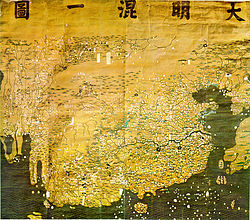
Le Da Ming Hun Yi Tu, ou la carte amalgamée du grand empire Ming (en mandarin: 大明混一图; pinyin: dàmíng hùnyī tú- en mandchou: dai ming gurun-i uherilehe nirugan), est une carte du monde créée en Chine. Elle a été peinte en couleur sur une mousseline de soie et mesure 386 × 456 cm.
Sa date exacte de réalisation reste inconnue.
Des étiquettes écrites en mandchou ont été superposées au texte original écrit en chinois classique.
La carte, centrée sur la Chine, représente l'Ancien Monde, entre la Mongolie au nord et Java au sud et entre le Japon à l'est et l'Europe à l'ouest.
Historique
Cette section est vide, insuffisamment détaillée ou incomplète.
Votre aide est la bienvenue !
Notes et références
Liens externes
Wikimedia Foundation.
2010.
Contenu soumis à la licence CC-BY-SA. Source : Article Da Ming Hun Yi Tu de Wikipédia en français (auteurs)
Regardez d'autres dictionnaires:
Da Ming Hun Yi Tu — (characters in right to left order) The Great Ming Amalgamated Map or Da Ming Hun Yi Tu (Chinese: 大明混一圖; pinyin: dàmíng hùnyī tú, Manchu: dai ming gurun i uherilehe nirugan) is a world map created in China. It was painted in colour on stiff silk… … Wikipedia
Ming Chuan University — Established 1957 Type Private (family owned) President Lee Chuan (李銓) Academic staff … Wikipedia
Ming Chuan University FC — is an association football club from Taiwan. They play at the highest division of Taiwan and their home venue is Taichung Football Field. This stadium has a capacity of 5,000. External links Ming Chuan University logo … Wikipedia
Islam during the Ming Dynasty — As the Yuan Dynasty ended, many Mongols as well as the Muslims who came with them remained in China. Most of their descendants took Chinese names and became part of the diverse cultural world of China.Richard Bulliet, Pamela Crossley, Daniel… … Wikipedia
Liste der Biografien/Hun — Biografien: A B C D E F G H I J K L M N O P Q … Deutsch Wikipedia
Early world maps — Ptolemy s world map (2nd century) in a 15th century reconstruction Early world maps cover depictions of the world from the Iron Age to the Age of Discovery and the emergence of modern geography during the early modern period … Wikipedia
Chinese geography — See also: Geography of China The oldest surviving Chinese world map, Da Ming Hun Yi Tu Native Chinese geography begins in the Warring States period (5th century BC). It expands its scope beyond the Chinese homeland with the growth of the Chinese… … Wikipedia
Kangnido — Infobox Korean name title=Gangnido map (1402) imgwidth=350px hangul=혼일강리역대국도지도 hanja=混一疆理歷代國都之圖 rr=Honil gangni yeokdae gukdo jido mr=Honil gangni yŏktae gukto jido othername1=Short name hangul1=강리도 hanja1=疆理圖 rr1=Gangnido mr1=Kangnido|The Honil… … Wikipedia
Islam during the Yuan Dynasty — The establishment of the Yuan Dynasty in China had dramatically benefited Islam in China in contrast to previous dynasties. Muslims in China were given an elevated status in the hierarchy of the new regime. The impact on China by its Muslims at… … Wikipedia
Géographie chinoise — Demande de traduction Chinese geography → … Wikipédia en Français
 Da Ming Hun Yi Tu
