Bouraoui Belhadef

Bouraoui Belhadef
Bouraoui Belhadef

Ajouter une image

Administration
Nom algérien بوراوى بلهادف
Pays Drapeau d'Algérie Algérie
Wilaya Jijel
Daïra El Ancer
Code postal 1816
Culture et démographie
Population 10 336 hab. (2008[1])
Géographie
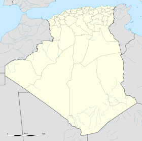
Coordonnées 36° 41′ 56″ N 6° 06′ 07″ E / 36.6988253, 6.102025536° 41′ 56″ N 6° 06′ 07″ E / 36.6988253, 6.1020255
Superficie km2
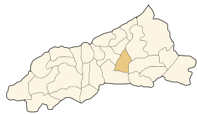
Voir la carte administrative
Bouraoui Belhadef
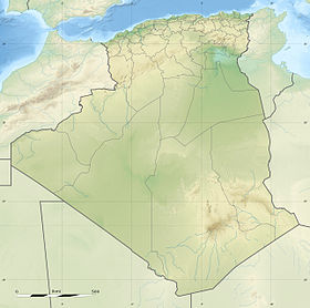
Voir la carte topographique
Bouraoui Belhadef
DZ - 18-16 - Bouraoui Belhadef - Wilaya de Jijel.svg
Localisation de la commune dans la wilaya de Jijel

Bouraoui Belhadef est une commune de la wilaya de Jijel en Algérie.

Sommaire

Géographie

Situation

Le territoire de la commune de Bouraoui Belhadef se situe au centre de la wilaya de Jijel.

Localités de la commune

La commune de Bouraoui Belhadef est composée de vingt-trois localités[2] :

  • Aouzourène
  • Beni Mimoune
  • Bouraoui Belhadef
  • Bousbaa
  • Bouyamème
  • Chdir El Kabch
  • Eddechra
  • El Teyana
  • En Nator
  • Er Rekaa El Hamra (Samâa)
  • Es Sebt
  • Gourmaten (Remila)
  • Mekhled
  • Ouled Amrane
  • Ouled Khellas
  • Ouled Maafi
  • Ouled Messaouda
  • Ouled Mezni
  • Taaret
  • Taoulout
  • Taria
  • Tassera
  • Touadna

Histoire

Notes et références

  1. [PDF]Recensement 2008 de la population algérienne, wilaya de Jijel, sur le site de l'ONS.
  2. Journal officiel de la République Algérienne, 19 décembre 1984. Décret n° 84-365, fixant la composition, la consistance et les limites territoriale des communes. Wilaya dde Jijel, page 1522.

Wikimedia Foundation. 2010.

Contenu soumis à la licence CC-BY-SA. Source : Article Bouraoui Belhadef de Wikipédia en français (auteurs)

Игры ⚽ Нужна курсовая?

Regardez d'autres dictionnaires:

  • Bordj Tahar — Ajouter une image Administration Nom algérien برج الطهر Pays  Algerie !Algérie …   Wikipédia en Français

  • Ouled Yahia Khedrouche — Ajouter une image Administration Nom algérien أولاد يحيى خدروش Pays  Algerie !Algé …   Wikipédia en Français

  • Djemaa Beni Habibi — Vue de Djemaa Beni Habibi Administration Nom algérien الجمعة بنى حبيبى Pays …   Wikipédia en Français

  • Djemaa Beni Habibi — is a municipality in Jijel province. It is located in the Northeast of the province and close to the Mediterranean coast, at 40 km Eastern Jijel s City centre and 90 km Northwest Constantine City. Its territory (48.25 km²) is bounded by the west… …   Wikipedia

  • Boucif Ouled Askeur — Ajouter une image Administration Nom algérien بوسيف أولاد عسكر Pays  Algerie !Algérie …   Wikipédia en Français

  • El Ancer —  Pour l’article homophone, voir El Anceur (homonymie). El Ancer Ajouter une image Administration Nom algérien العنصر Pays …   Wikipédia en Français

  • Jijel — Coordinates: 36°48′N 5°46′E / 36.8°N 5.767°E / 36.8; 5.767 …   Wikipedia

  • Communes of Algeria — Algeria This article is part of the series: Politics and government of Algeria Constitution President (List …   Wikipedia

  • List of municipalities in Jijel — This is a list of municipalities in the Algerian province of Jijel, in alphabetical order:#Bordj Taher #Boucif Ouled Askeur #Boudria Beni Yadjis #Bouraoui Belhadef #Chahana #Chekfa #Djemaa Beni Habibi #Djmila #El Ancer #El Aouana #El Kennar… …   Wikipedia

  • El Ancer District — Infobox Algerian District map1 = DZ 18.svg map2 = El Ancer District.svg name1 = El Ancer name2 = العنصر province = Jijel capital = El Ancer municipalities = 4 code = chef = order = 1 E+8 m² area1 = 263,94 area2 = 101,9 population = 47.347 popyear …   Wikipedia

Share the article and excerpts

Direct link
Do a right-click on the link above
and select “Copy Link”