Beachborough
- Beachborough
-
Beachborough est un hameau de Folkestone dans le Kent. Il se trouve au sud de Etchinghill.
Origine du nom
Anciennement Bilsborough
Vie du hameau
Il y à un parc unique autour de Beachborough Manor
Transports
Routes
Trains
- Gare de Sandling situé à 4.7Km
Communes Limitrophes
Annexes
Voir aussi
Autres projets
Sur les autres projets Wikimedia :
Wikimedia Foundation.
2010.
Contenu soumis à la licence CC-BY-SA. Source : Article Beachborough de Wikipédia en français (auteurs)
Regardez d'autres dictionnaires:
Beachborough — infobox UK place country = England static static image caption=Beachborough House latitude= 51.10 longitude=1.1 official name=Beachborough population = shire district= Shepway shire county = Kent region= South East England constituency… … Wikipedia
Beachborough Manor — was a manor in Beachborough, Kent, UK purchased by Sir William s great grandfather Father Henry Brockman ca. 1500 and subsequently passed through various squires in the English Brockman family. Like many buildings in the UK, it found use in World … Wikipedia
Brockman — The Brockman surname is not common, but has spread to several countries around the world. The name can be a topism combining wet/water and man . However, in Old English and in heraldry a brock is also a badger, and some have claimed it to mean… … Wikipedia
Newington, Shepway — See Newington for other places of that name Coordinates: 51°05′31″N 1°06′52″E / 51.092°N 1.1144°E / 51.092; 1.1144 … Wikipedia
Markham Baronets — There have been two Baronetcies created for persons with the surname Markham, one in the Baronetage of England and one in the Baronetage of the United Kingdom. The Markham Baronetcy, of Sedgebrooke in the County of Lincoln, was created in the… … Wikipedia
List of historic houses in England — Historic houses in England is a link page for any stately home, country house or other historic house in England.Bedfordshire*Ampthill Park *Battlesden House *Chicksands Priory *Eggington House *Hinwick House *Houghton House *Luton Hoo *Milton… … Wikipedia
New Romney — For the former parliamentary borough, see New Romney (UK Parliament constituency). Coordinates: 50°59′06″N 0°56′28″E / 50.985°N 0.941°E / … Wikipedia
Grendon Underwood — infobox UK place country = England latitude= 51.8832 longitude= 1.0173 population= 1,541 [ [http://www.neighbourhood.statistics.gov.uk/dissemination/LeadTableView.do?a=7 b=792044 c=grendon+underwood d=16 e=15 g=424225 i=1001x1003x1004 m=0 r=1… … Wikipedia
Dungeness (headland) — This article is about the headland in Kent, England. For the spit in Washington, United States, see Dungeness Spit. For the headland on the border of Chile and Argentina, see Punta Dúngeness. Coordinates: 50°55′00″N 0°58′00″E / … Wikipedia
Manor house — This article is about a type of historical building. For other uses, see Manor house (disambiguation). Ightham Mote, a 14th century moated manor house in Kent, England … Wikipedia
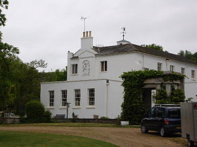 Beachborough House
 Angleterre
 Beachborough

