- Balakliia
-
Balakliia Балаклія 
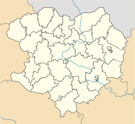
Géolocalisation sur la carte : Oblast de Kharkiv

Géolocalisation sur la carte : Ukraine
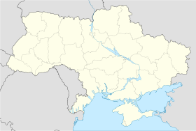
Coordonnées : Pays  Ukraine
Subdivision  Oblast de Kharkiv
Maire Valeriï Jourava Fondation 1663 Statut Ville depuis 1938 Population  29 676 hab. (2011)
Densité 176 hab./km² Superficie 168,68 km2 Indicatif tél. +380 5749 Code postal 64218 Liste des villes d'Ukraine | Carte Balakliia (en ukrainien : Балаклія) ou Balakleïa (en russe : Бaлaклeя) est une ville de l'oblast de Kharkiv, dans l'est de l'Ukraine, et le centre administratif du raïon de Balakliia. Sa population s'élevait à 29 676 habitants en 2011.
Sommaire
Géographie
Balakliia est arrosée par la rivière Donets et se trouve à 74 km au sud-est de Kharkiv.
Histoire
La fondation de Balakliia remonte à 1663. Elle a le statut de ville depuis 1938. Pendant la Seconde Guerre mondiale, de très violents combats se déroulèrent dans les environs de Balakliia. Pendant la deuxième bataille de Kharkov, la Wehrmacht et l'Armée rouge s'affrontèrent en mai 1942, faisant des dizaines de milliers de morts parmi les officiers et soldats soviétiques.
Population
La population de Balakliia a fortement baissé au cours des dernières années. Recensements (*) ou estimations de la population [1] :
Évolution démographique 1959* 1970* 1979* 1989* 2001* 2008 2009 2010 2011 21 325 30 470 32 820 37 737 32 408 30 042 29 909 29 781 29 676 Économie
Une des principales entreprises de Balakliia est la société Baltsem (en ukrainien : Балцем), qui produit du ciment depuis 1969. Elle a une capacité de 3 millions de tonnes par an et emploie 1 900 salariés (2006).
Notes et références
- (ru) Recensements de 1959, 1970 et 1979 sur www.webgeo.ru — (en) World Gazetteer [1] — (uk) Office des statistiques d'Ukraine : Статистичний збірник «Чисельність наявного населення України на 1 січня 2008 року» [Manuel statistique « Nombre d'habitants de l'Ukraine au 1er janvier 2008 »]. [2] ; Статистичний збірник «Чисельність наявного населення України на 1 січня 2010 року» [Manuel statistique « Nombre d'habitants de l'Ukraine au 1er janvier 2010 »]. [3] ; Статистичний збірник «Чисельність наявного населення України на 1 січня 2011 року» [Manuel statistique « Nombre d'habitants de l'Ukraine au 1er janvier 2011 »]. [4]
Liens externes
- (uk) Informations officielles
- (ru) Cartes topographiques
- (uk) Carte routière
Catégories :- Ville d'Ukraine
- Ville de l'oblast de Kharkiv


Wikimedia Foundation. 2010.