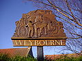
Weybourne
- Weybourne
-
Weybourne est un village du comté de Norfolk en Angleterre, situé de part et d'autre de la route côtière, à quatre kilomètres à l'ouest de Sheringham. Le village est entouré de champs arables, bois et terres. L'endroit est dit excellent pour profiter de promenades typiques à la campagne et sur la côte. L'observation de la vie sauvage et en particulier des oiseaux y est très populaire.
Histoire
Dans le recensement Domesday Book réalisé pour Guillaume le Conquérant en 1086, le village est mentionné sous le nom de Wabrume. Il reste des traces d'un prieuré des augustins, fondé par Sir Ralph de Meyngaren (Mainwearing) vers le début du XIIIe siècle là à l'emplacement d'une petite église saxonne. En 1494, seul un prieur et trois chanoines y vivaient ; l'un de ces derniers se plaignit que le prieuré fût si pauvre qu'il ne pouvait pas lui payer ses 20 shillings annuels. En 1514, il n'y avait plus qu'un prieur et un chanoine, et il en fut ainsi jusqu'à ce qu'Henri VIII ordonnât la dissolution des monastères et prieurés.
Personnalités liées à la commune
Références et liens
Wikimedia Foundation.
2010.
Contenu soumis à la licence CC-BY-SA. Source : Article Weybourne de Wikipédia en français (auteurs)
Regardez d'autres dictionnaires:
Weybourne — Infobox UK place official name= Weybourne country= England region= East of England shire district= North Norfolk shire county= Norfolk civil parish= Weybourne static static image caption = The village sign population= 518 (parish, 2001 census)… … Wikipedia
Weybourne (disambiguation) — Weybourne can refer to one of two places in England: *Weybourne, Norfolk *Weybourne, Surrey … Wikipedia
Weybourne, Surrey — infobox UK place country = England official name= Weybourne map type= Surrey latitude= 51.23 longitude= 0.78 population=4176 (including Badshot Lea) [ [http://neighbourhood.statistics.gov.uk/dissemination/LeadKeyFigures.do;jsessionid=ac1f930dce6cf… … Wikipedia
Weybourne Windmill — Geobox|Windmill name = Weybourne Windmill category = Windmill image caption =Weybourne Windmill symbol = country = England state = Norfolk region = East of England district = North Norfolk municipality = Weybourne location =Village of Weybourne… … Wikipedia
Weybourne railway station — Infobox UK heritage station name = Weybourne caption = Weybourne railway station owner = Midland and Great Northern Joint Railway London North Eastern Railway Eastern Region of British Railways North Norfolk Railway locale = Weybourne borough =… … Wikipedia
North Norfolk Railway — Weybourne station Locale … Wikipedia
Spring Beck (Norfolk) — Spring Beck is a minor watercourse in the north of the County of NorfolkThis small short Beck rises in a substantial hollow on the edge of Hundred Acre Wood in an area called Weybourne Pits close to Weybourne railway station. From its spring it… … Wikipedia
Muckleburgh Collection — The Muckleburgh Collection Military Museum Harrier on display at the museum … Wikipedia
A149 road — UK road routebox road= A149 length mi= 85.2 length km= direction= West to east start= Kings Lynn destinations= Cromer end= Great Yarmouth construction date= completion date= junctions= ukroadsmall|10 ukroadsmall|47 ukroadsmall|148 ukroadsmall|140 … Wikipedia
Kelling — For the place in Romania, formerly called Kelling, see Câlnic, Gorj. Infobox UK place official name= Kelling country= England region= East of England shire district= North Norfolk shire county= Norfolk civil parish= Kelling static static image… … Wikipedia

 Angleterre
