Waarschoot
- Waarschoot
-
 Waarschoot Waarschoot |
|
|
|
|
|
| Géographie |
| Pays |
 Belgique Belgique |
| Région |
 Région flamande Région flamande |
| Communauté |
Communauté flamande |
| Province |
 Province de Flandre-Orientale Province de Flandre-Orientale |
| Arrondissement |
Gand |
| Coordonnées |
51° 09′ N 3° 36′ E / 51.15, 3.651° 09′ Nord
3° 36′ Est / 51.15, 3.6 |
Superficie
– Surface agricole
– Bois
– Terrains bâtis
– Divers |
21,91 km² (2005)
75,48 %
7,72 %
16,10 %
0,70 % |
| Données sociologiques |
Population
– Hommes
– Femmes
Densité |
7 776 (1er janvier 2008)
49,82 %
50,18 %
355 hab./km² |
Pyramide des âges
– 0–17 ans
– 18–64 ans
– 65 ans et + |
(1er janvier 2008)
18,93 %
61,50 %
19,57 % |
| Étrangers |
1,12 % (1er janvier 2008) |
| Économie |
| Taux de chômage |
5,78 % (janvier 2009) |
| Revenu annuel moyen |
13 721 €/hab. (2005) |
| Politique |
| Bourgmestre |
Ghislain Lippens (CD&V) |
| Majorité |
CD&V, WGB |
Sièges
CD&V
VLD
WGB
sp. a |
19
8
7
3
1 |
| Sections de commune |
| Section |
Code postal |
| Waarschoot |
9950 |
| Autres informations |
| Gentilé |
(inconnu) |
| Zone téléphonique |
09 |
| Code INS |
44072 |
| Site officiel |
www.waarschoot.be |
modifier  |
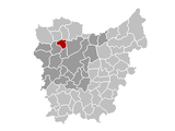
Waarschoot est une commune néerlandophone de Belgique située en Région flamande, dans la province de Flandre-Orientale.
Catégorie :
- Commune de la province de Flandre-Orientale
Wikimedia Foundation.
2010.
Contenu soumis à la licence CC-BY-SA. Source : Article Waarschoot de Wikipédia en français (auteurs)
Regardez d'autres dictionnaires:
Waarschoot — Waarschoot … Deutsch Wikipedia
Waarschoot — (spr. schōt, franz. Waerschoot), Flecken in der belg. Provinz Ostflandern, Arrond. Gent, an der kanalisierten Lieve und der Staatsbahnlinie Gent Brügge, mit Fabrikation von Baumwollwaren, Leinwand, Zwillich, Müllerei und (1905) 6144 Einw … Meyers Großes Konversations-Lexikon
Waarschoot — Infobox Belgium Municipality name=Waarschoot picture= picture map arms=Waarschoot wapen.gif region=BE REG FLE community=BE NL province=BE PROV OV arrondissement=Ghent nis=44072 pyramid date= 0 19= 20 64= 65= foreigners= foreigners date=… … Wikipedia
Waarschoot — Original name in latin Waarschoot Name in other language Waarschoot, Waerschoot State code BE Continent/City Europe/Brussels longitude 51.1525 latitude 3.605 altitude 6 Population 7762 Date 2012 01 18 … Cities with a population over 1000 database
Waarschoot — Sp Várschotas Ap Waarschoot flamandiškai (olandų k. tarme) L Belgija … Pasaulio vietovardžiai. Internetinė duomenų bazė
Waerschoot — Waarschoot Waarschoot … Wikipédia en Français
Raymond Decorte — Infobox Cyclist ridername = Raymond Decorte fullname = Raymond Decorte nickname = dateofbirth = birth date|1898|03|17 dateofdeath = death date and age|1972|03|30|1898|03|17 country = BEL height = weight = currentteam = discipline = Road role =… … Wikipedia
Arrondissement administratif de Gand — 51° 03′ N 3° 42′ E / 51.05, 3.7 … Wikipédia en Français
Arrondissement of Ghent — Infobox Belgium Arrondissement name=Ghent map East Flanders region=BE REG FLE province=BE PROV OV area=943.62 population=508,996 population date=01/01/2006 municipalities=21The Arrondissement of Ghent ( nl. Arrondissement Gent; fr. Arrondissement … Wikipedia
Alost — Aalst … Deutsch Wikipedia