- Stranorlar
-
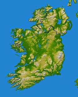
Stranorlar Administration Nom irlandais Srath an Urláir Pays Irlande Province Ulster Comté Comté de Donegal Site web Consulter Démographie Population 4 176[1] hab. (2006) Géographie Coordonnées Stranorlar (Irlandais : Srath an Urláir, « la vallée à fond plat ») est une petite ville du Comté de Donegal (Ulster), dans la vallée de la rivière Finn, au nord-ouest de l'Irlande. Avec sa voisine Ballybofey, située sur l'autre rive, elles forment les Twin Towns (villes jumelles) Ballybofey-Stranorlar.
Sommaire
Transports
Stranorlar est établie à la jonction des routes nationales N13 et N15. Pendant presque cent ans, de 1863 à 1961, elle abritait le siège du County Donegal Railway System (à l'origine, la Finn Valley Railway), qui desservait Derry et Letterkenny via Strabane, Ballyshannon et Killybegs via Donegal, et Glenties. À son apogée la compagnie employait 130 personnes. Le dernier train partit de Stranorlar en 1961. La gare ferroviaire a été démolie et remplacée par une gare routière appartenant à la compagnie Bus Éireann. À l'occasion des fêtes du millénaire, l'ancienne horloge de la gare a été restaurée et installée dans une nouvelle tour.
À Stranorlar se trouve le principal dépôt de Bus Éireann pour le comté de Donegal.
Éducation
La ville est équipée de deux collèges, St Columba's College et Finn Valley College, et de deux écoles primaire : St Mary's primary school qui jouxte l'église catholique, et la Robertson National School en face de l'Église d'Irlande (Church of Ireland).
Religion
La vieille église de l'Église d'Irlande est intéressante, et son cimetière abrite la tombe d'Isaac Butt, le fondateur de la Home Rule League.
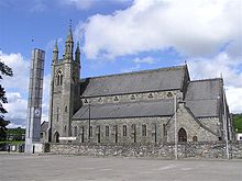
Le culte catholique est pratiqué à l'église St Mary ; la ville est également pourvue de deux églises presbytériennes.
Sport
Les pistes d'athlétisme du Finn Valley Athletics Club sont installées à Stranorlar ; la ville bénéficie également d'un golf 18 trous. La Finn permet de pratiquer la pêche de loisir.
Tourisme
La principale attraction de Stranorlar est Drumboe Woods[2]. Cette forêt, gérée par le Coillte[3], est parcourue de sentiers de promenade, le long des berges de la Finn et des bois environnants.
À l'extérieur de la ville, The Steeple est une folie, lieu de promenade très populaire ; du haut de sa tour, on peut apercevoir par temps clair le fort du Grianan d'Aileach. Dans les alentours se trouve un intéressant ringfort à Dunwiley.
Le commerce s'étant plutôt développé dans sa jumelle Ballybofey, Stranorlar est essentiellement une zone résidentielle. Son architecture, en grande partie du XIXe siècle, est constituée d'immeubles de deux ou trois étages.
Voir aussi
Notes et références
- Population totale de l'agglomération Ballybofey-Stranorlar CSO Census Site
- (en) FinnValley.ie : Drumboe Woods
- (en) Coillte : Site officiel
Catégorie :- Ville du Comté de Donegal
Wikimedia Foundation. 2010.


