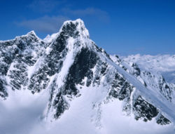
Store Styggedalstinden east
- Store Styggedalstinden east
-
Storen
Le Storen est une montagne norvégienne de 2405 mètres.
le Store Styggedalstinden
|
 Portail de la Norvège
 Portail de la montagne
Catégories : Montagne de Norvège | Sommet d'Europe
Wikimedia Foundation.
2010.
Contenu soumis à la licence CC-BY-SA. Source : Article Store Styggedalstinden east de Wikipédia en français (auteurs)
Regardez d'autres dictionnaires:
Alpes Scandinaves — Carte des Alpes scandinaves. Géographie Altitude 2 469 m … Wikipédia en Français
Alpes scandinaves — Carte des Alpes scandinaves. Géographie Altitude 2 469 m, Galdhøpiggen Longueur 1 700� … Wikipédia en Français
Scandes — Alpes scandinaves Alpes scandinaves Carte des Alpes scandinaves. Géographie Altitude 2 469 m … Wikipédia en Français
Scandinavian Mountains — The Scandinavian Mountains, in Swedish Skanderna , Fjällen ( the Fells ) or Kölen , and in Norwegian Kjølen , with the two latter meaning the Keel, are a mountain range that runs through the Scandinavian Peninsula. The western sides of the… … Wikipedia
Midtre Skagastølstind — Elevation 2,284 m (7,493 ft) … Wikipedia

 Norvège


