Sint-philipsland

Sint-philipsland

Sint-Philipsland

Sint-Philipsland
Map NL - Tholen - Sint Philipsland.png
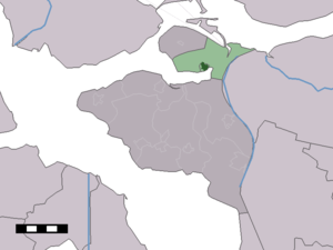
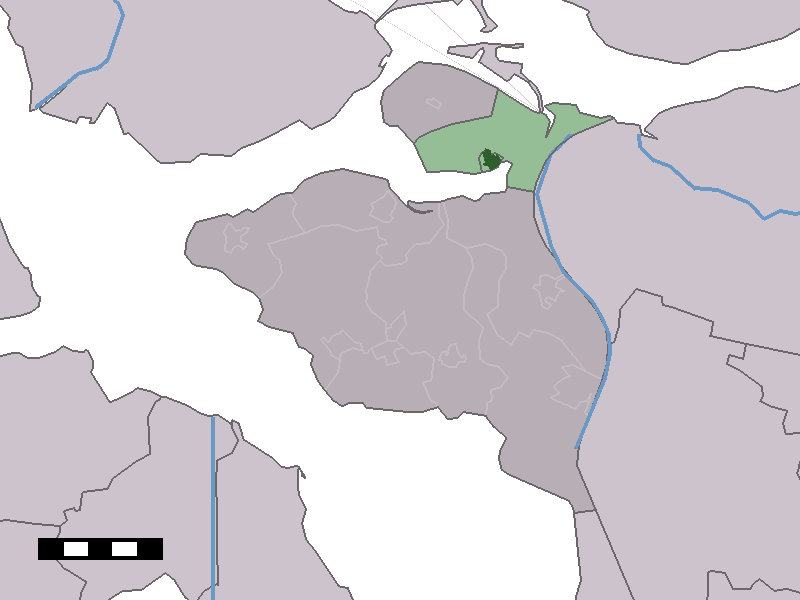
Vue de la localité sur la carte des Pays-Bas

Pays Pays-Bas Pays-Bas
Commune Tholen
Province Zélande
Nombre d'habitants ca 2 500 ()
Code postal 4675

Sint-Philipsland est un village et une presqu'île (anciennement, c'était une île) zélandaise, aux Pays-Bas. Elle forme avec la presqu'île de Tholen la commune de Tholen. Sint-Philipsland compte environ 2 500 habitants pour une superficie d'environ 23 km².

Histoire

La première poldérisation de l'actuel Sint-Philipsland a eu lieu en 1487, sur l'initiative d'Anne de Bourgogne, fille bâtarde du duc Philippe de Bourgogne. Il est probable qu'il a donné son nom à l'île et au village (Terre Saint-Philippe). En 1530 et en 1532, les polders sont inondés suite à des grandes tempêtes. Les digues ne sont rétablies qu'en 1645. Depuis 1937, la presqu'île a sa forme actuelle.

Jusqu'en 1995, année de sa fusion avec Tholen, la presqu'île était une commune indépendante.

Localités

Outre le village de Sint-Philipsland, on y trouve le village d'Anna Jacobapolder et le hameau de De Sluis.

Lien interne

  • Portail des Pays-Bas Portail des Pays-Bas
Ce document provient de « Sint-Philipsland ».

Wikimedia Foundation. 2010.

Contenu soumis à la licence CC-BY-SA. Source : Article Sint-philipsland de Wikipédia en français (auteurs)

Игры ⚽ Поможем сделать НИР

Regardez d'autres dictionnaires:

  • Sint-Philipsland — Flagge Wappen Provinz …   Deutsch Wikipedia

  • Sint-Philipsland — 51° 37′ 01″ N 4° 09′ 52″ E / 51.61694444, 4.16444444 …   Wikipédia en Français

  • Sint Philipsland — Dutch town locator maps mun town caption = The village centre (dark green) and the statistical district (light green) of Sint Philipsland in the municipality of Tholen.Sint Philipsland (coord|51|37|N|4|10|E|type:city(2002)) is a village in the… …   Wikipedia

  • Sint Philipsland — Sp Sint Filipslandas Ap Sint Philipsland L Nyderlandai …   Pasaulio vietovardžiai. Internetinė duomenų bazė

  • Sint Philipsland — Sp Sint Filipslandas Ap Sint Philipsland L Olandija …   Pasaulio vietovardžiai. Internetinė duomenų bazė

  • Sint Philipsland (Insel) — Lage der Halbinsel Sint Philipsland Sint Philipsland auf einer …   Deutsch Wikipedia

  • Sint Maartensdijk — Flagge Wappen Provinz …   Deutsch Wikipedia

  • Sint Maartensdijk — 51°32′52″N 4°4′30″E / 51.54778, 4.075 …   Wikipédia en Français

  • Sint-Maartensdijk — 51°32′52″N 4°4′30″E / 51.54778, 4.075 …   Wikipédia en Français

  • Sint-Annaland — 51°35′59″N 4°6′10″E / 51.59972, 4.10278 …   Wikipédia en Français

Share the article and excerpts

Direct link
Do a right-click on the link above
and select “Copy Link”