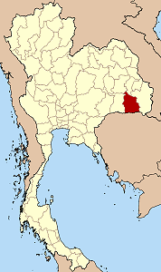
Province de Si Sa Ket
- Province de Si Sa Ket
-
Province de Si Saket
|
|
| Pays |
 Thaïlande Thaïlande |
| Capitale |
Sisaket |
| Superficie |
8 840 km²
21e rang |
| Population |
1 468 256 (2000)
9e rang |
| Densité |
159 hab./km²
20e rang |
| ISO3166-2 |
TH-33 |
 |
La Province de Si Saket (Thaï: ศรีสะเกษ) se situe dans la région Nord-Est de la Thaïlande.
La province de Si Saket se situe entre les provinces de Surin, Ubon Ratchathani, Roi Et et Yasothon. Au sud, elle est délimitée par la frontière cambodgienne. Elle est composée de 20 districts administratifs dont Amphur Uthumphon Phisaï (Thaï: อุทุมพรพิสัย).
La province est traversée par la rivière Mae Nam Mun (Thaï: แม่น้ำมูล), l'un des principaux affluents du fleuve Mékong.
Il est possible de visiter le fameux sanctuaire Prasat Khao Phra Wihan, chef d'œuvre de l'architecture khmère. Bien que situées au Cambodge, les ruines sont plus faciles d'accès depuis la Thaïlande.
Catégories : Province de Thaïlande | Isan
Wikimedia Foundation.
2010.
Contenu soumis à la licence CC-BY-SA. Source : Article Province de Si Sa Ket de Wikipédia en français (auteurs)
Regardez d'autres dictionnaires:
Samut Prakan Province — Infobox Thai Province name = Samut Prakan thai = สมุทรปราการ capital = Samut Prakan area = 1,004.1 arearank = 70th population = 1,126,485 population as of = 2007 populationrank = 18th density = 1122 densityrank = 3rd governor = Anuwat… … Wikipedia
Mueang Si Sa Ket District — Mueang Sisaket เมืองศรีสะเกษ Amphoe Amphoe location in Sisaket Province … Wikipedia
Ang Thong Province — Ang Thong อ่างทอง Province … Wikipedia
Roi Et Province — Infobox Thai Province name = Roi Et thai = ร้อยเอ็ด capital = Roi Et town area = 8,299.4 arearank = 23rd population = 1,256,458 population as of = 2000 populationrank = 11th density = 151 densityrank = 23rd isocode = TH 45 governor = Phinit… … Wikipedia
Prachaup Province — Prachuap Khiri Khan ประจวบคีรีขันธ์ Statistik Hauptstadt: Prachuap Khiri Khan Tel.vor … Deutsch Wikipedia
bread|bas|ket — «BREHD BAS kiht, BAHS », noun. 1. a basket or tray for holding or carrying bread. 2. Figurative. a region that is a chief source of grain: »... Alentejo, the rich breadbasket province of rolling wheat and cork groves (Atlantic). 3. Slang,… … Useful english dictionary
Amphoe Mueang Si Sa Ket — Infobox Amphoe name=Mueang Sisaket thai=เมืองศรีสะเกษ province=Sisaket coordinates=coord|15|7|14|N|104|19|20|E|type:adm2nd region:TH area=576.366 population=134,826 population as of=2005 density=233.9 postal code=33000 geocode=3301Mueang Sisaket… … Wikipedia
Vehicle registration plates of Thailand — Thailand vehicle license plates ( th. แผ่นป้ายทะเบียนรถ or หมายเลขทะเบียนรถ or simply ทะเบียนรถ) are the license plates attached to most motorized road vehicles in Thailand, which are required by law. Thai license plates display the name of the… … Wikipedia
Japanese invasions of Korea (1592–1598) — Infobox Military Conflict conflict=Japanese invasions of Korea date=1592–1598 caption= The Japanese landing on Busan. place=Korean peninsula result=Korean and Chinese victory. combatant1=Korea under the Joseon Dynasty, China under the Ming… … Wikipedia
Flanaess — The Flanaess is the eastern part of the continent of Oerik, one of the four continents of the fictional world of Oerth in the World of Greyhawk campaign setting for the Dungeons Dragons fantasy roleplaying game. The Flanaess has been the setting… … Wikipedia
 Thaïlande
