Portolan
- Portolan
-
Portulan
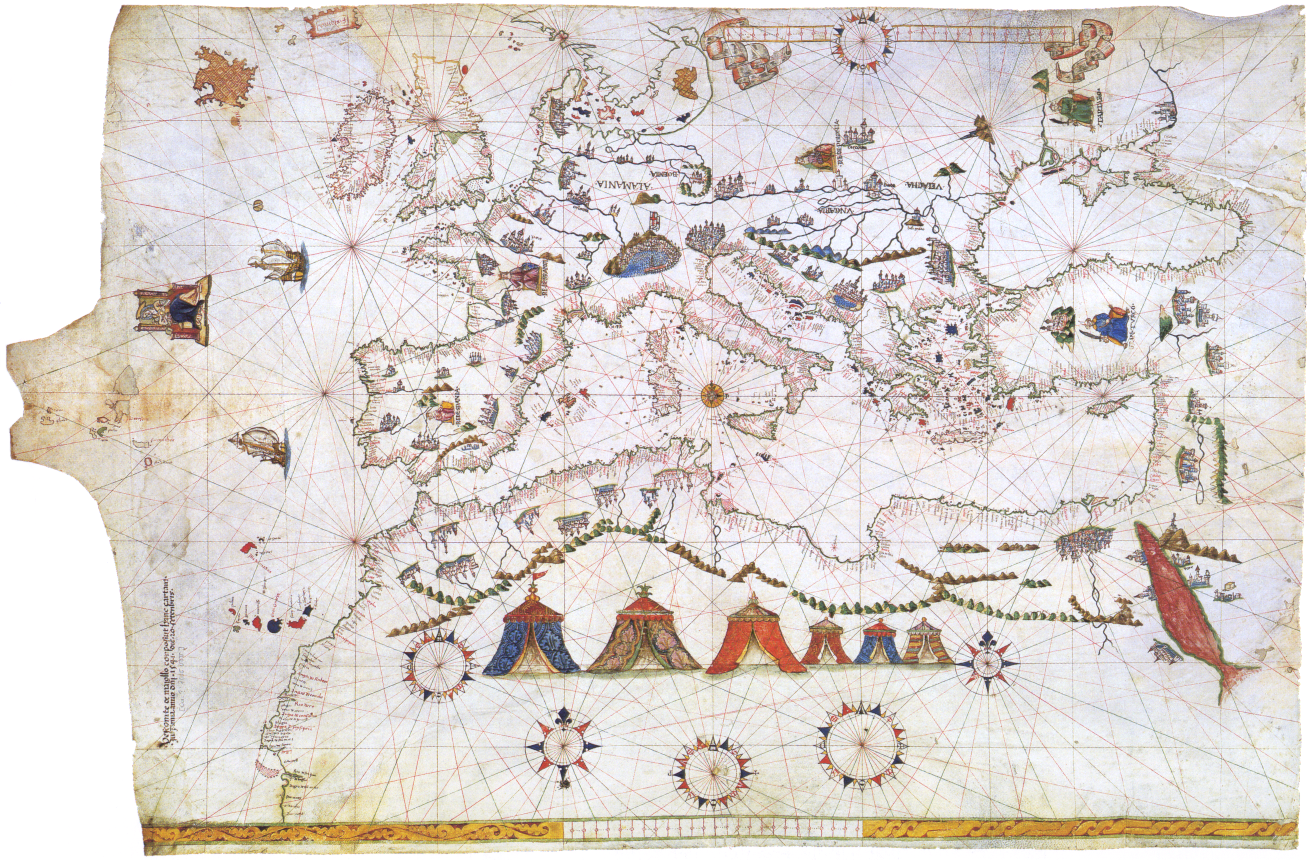
Un portulan (dans beaucoup de langues portolan), au XIVe siècle ou plus tard, était une sorte de carte nautique servant essentiellement à repérer les ports et connaître les dangers qui pouvaient les entourer : courants, bas-fonds... Les portulans étaient grossièrement dessinés, les détails ne s'attachant qu'à ce qui avait de l'importance pour la navigation. L'établissement de ces cartes nautiques était basé sur un mode de navigation par cabotage.
Un portulan est fondé sur des observations et des relevés faits à la boussole. Pour juger de la pertinence ou de la qualité de ces véritables cartes de navigation, il faut y appliquer la déclinaison magnétique... depuis des siècles.
Le plus vieux portulan connu date de 1296, dans une charte napolitaine. Le cartographe Angelino Dulcert en a réalisé un en 1339.
Voir aussi
Articles connexes
Liens externes
 Portail du monde maritime
Catégories : Cartographie | Nautisme
Wikimedia Foundation.
2010.
Contenu soumis à la licence CC-BY-SA. Source : Article Portolan de Wikipédia en français (auteurs)
Regardez d'autres dictionnaires:
portolan — portòlān m DEFINICIJA v. portulan ETIMOLOGIJA vidi portulan … Hrvatski jezični portal
Portolan — Weltkarte des Juan de la Cosa (1500) … Deutsch Wikipedia
Portolan — Por|to|lan: ↑Portulan. Por|tu|lan, Portolan, der; s, e [ital. portolano < mlat. portulanus, zu lat. portus = Hafen]: mittelalterliche Navigationsanleitung für Seefahrer … Universal-Lexikon
Portolan chart — A portolan (derived from the Latin word portus , port) is an early modern European navigation chart, dating from the thirteenth century or later, in manuscript, usually with rhumb lines, shorelines and place names.The portolan combined the exact… … Wikipedia
portolan chart — also called Harbour finding Chart, Compass Chart, or Rhumb Chart, navigational chart of the European Middle Ages (1300–1500). The earliest dated navigational chart extant was produced at Genoa by Petrus Vesconte in 1311 and is said to… … Universalium
portolan — noun an early chart of European navigable waters … Wiktionary
Portolan — Por|to|lan vgl. ↑Portulan … Das große Fremdwörterbuch
portolan — [ pɔ:təlan] (also portolano ˌpɔ:tə lα:nəʊ) noun (plural portolans or portolanos) historical a book of sailing directions with charts and descriptions of harbours and coasts. Origin C19: from Ital. portolano, from porto harbour … English new terms dictionary
portolan — por·to·lan … English syllables
portolan — n. (also portolano) (pl. portolans or portolanos) hist. a book of sailing directions with charts, descriptions of harbours, etc. Etymology: It. portolano f. porto PORT(1) … Useful english dictionary
 Un portulan de 1541