Port Hood
- Port Hood
-
Port Hood ou Juste-au-Corps est une ville canadienne du comté d'Inverness, dont elle est le chef-lieu, sur l'île du Cap-Breton, en Nouvelle-Écosse.
Situation
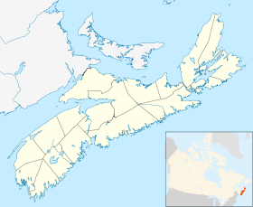
Port Hood est situé au bord du golfe du Saint-Laurent, sur la rive ouest de l'île du Cap-Breton.
Hameaux et lieux-dits
Port Hood comprend le village à proprement parler ainsi que les hameaux suivants: Colindale, Dungarry, Dunmore, Harbourview, Little Mabou, Marble Hill, Port Hood Island et Port Hood Station.
Histoire
Juste-au-Corps a été renommé en 1837 à la demande de Sir William Young, député du comté d'origine écossaise. Le nom Juste-au-Corps fut utilisé couramment par les Acadiens jusqu'à la fin du XIXe siècle, et l'est encore dans un contexte historique.
Wikimedia Foundation.
2010.
Contenu soumis à la licence CC-BY-SA. Source : Article Port Hood de Wikipédia en français (auteurs)
Regardez d'autres dictionnaires:
Port Hood — Port Hood, Hafen der Insel Breton (Britisch Nordamerika), Viehausfuhr nach Neufundland … Pierer's Universal-Lexikon
Port Hood, Nova Scotia — Port Hood coord|46|01|00|N|61|32|00|W|region:CA type:city|display=title is a quiet seaside village (2001 pop. 1462 [ [http://www.gov.ns.ca/finance/communitycounts/topicresults.asp?tnum=1 gval=com tsection= yval=2001 NS Community Counts] ] ) on… … Wikipedia
Port Hood Island, Nova Scotia — Port Hood Island is a small island located in the eastern part of the Northumberland Strait, immediately adjacent to the west coast of Cape Breton Island, Nova Scotia, Canada. It is named after the Cape Breton Island village of Port Hood which it … Wikipedia
Port Hood Consolidated School — was a school in Port Hood, Nova Scotia that was open from fall 1962 until spring 2000.EstablishmentThe construction of Port Hood Consolidated School began in the fall of 1961 and concluded in the spring of1962. The school was built to replace… … Wikipedia
Port Hawkesbury — Pour les articles homonymes, voir Hawkesbury (homonymie). Port Hawkesbury Administration Pays … Wikipédia en Français
Port Hastings — 45° 37′ 59″ N 61° 24′ 00″ W / 45.633, 61.4 Port Hastings est … Wikipédia en Français
Hood River, Oregon — City Hood River and the Columbia River, facing east … Wikipedia
Port Gamble — Ortseingang von Port Gamble Lage in Washington … Deutsch Wikipedia
Hood Canal — is a fjord off Puget Sound in the U.S. state of Washington. It is sometimes considered to be one of the four main basins of Puget Sound. [ftp://dnr.metrokc.gov/dnr/library/2001/kcr762/PDFELEMENTS/SONR03.pdf Features Of Puget Sound Region:… … Wikipedia
Port of Miami (album) — Port of Miami Studio album by Rick Ross Released August 8, 2006 … Wikipedia
 Canada
 Nouvelle-Écosse