Peak District
- Peak District
-
Parc national de Peak District
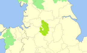
Le Peak District est un des douze parcs nationaux d'Angleterre et du Pays de Galles qui est situé au centre-nord de l'Angleterre, surtout sur le comté de Derbyshire, mais aussi sur Cheshire, Grand Manchester, Staffordshire, Yorkshire du Sud (Sheffield) et Yorkshire de l'Ouest (Kirklees). Il est le premier parc national, créé en 1951.
Géographie
Le parc est divisé en deux parties
- Au nord, le Dark Peak, un plateau de brande presque inhabité, est la partie la plus haute du parc, où se dresse Kinder Scout, la montagne la plus haute du parc, avec 636 mètres d'altitude; et Kinder Downfall, la chute d'eau la plus haute du parc.
- Au sud, le White Peak, région plus basse, où habite la majorité de la population du parc, où se trouvent des réservoirs et un bon réseau de sentiers. Le parc est le site d'un fond du Pennine Way, un sentier célèbre du Royaume-Uni.
Le principal cours d'eau du District est la Dove qui coule d'Axe Edge Moor jusqu'à son confluent avec la Trent.

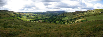
Panorama du Peak District, près du High Peak
Tourisme
Le parc est populaire pour l'équitation, la marche, la randonnée, le cyclisme, le spéléologie, le deltaplane, le parapente et l'escalade
Liens externes
 Portail du Royaume-Uni
 Portail de la conservation de la nature
Catégories : Aire protégée de l'UICN - catégorie II | Parc national du Royaume-Uni
Wikimedia Foundation.
2010.
Contenu soumis à la licence CC-BY-SA. Source : Article Peak District de Wikipédia en français (auteurs)
Regardez d'autres dictionnaires:
Peak District — Peak Dis|trict the Peak District a hilly area and ↑national park, mostly in Derbyshire, northern England, which is popular for climbing, walking, and ↑potholing … Dictionary of contemporary English
Peak District — [ piːk dɪstrɪkt], der südliche Teil des Penninischen Gebirges, Mittelengland, bis 636 m über dem Meeresspiegel (Kinder Scout); von Wollgrasdeckenmooren und Zwergstrauchheiden bedeckt; seit 1950/51 Nationalpark (1 404 km2); Heilbad Buxton … Universal-Lexikon
Peak District — Geobox|Protected Area name = Peak District native name = other name = other name1 = category local = National Park of England category iucn = V |240px image size = image caption = Peak District entrance stone on Hathersage Road, Sheffield country … Wikipedia
Peak District — Das Peak District ist ein Hochland Gebiet, das sich in Zentral und Nordengland befindet. Der Peak District ist das südliche Ende der Pennines. Große Teile des Gebietes liegen über 300 m hoch, der höchste Punkt ist der Gipfel des Kinder Scout mit… … Deutsch Wikipedia
Peak District — an area of hills, valleys, moors (= high land that is not cultivated) and caves, mostly in north Derbyshire, England. It has been a national park since 1951 and is very popular with people who enjoy walking and climbing. * * * ▪ region, England,… … Universalium
Peak-District-Nationalpark — Peak District Nationalpark … Deutsch Wikipedia
Peak District National Park — Der Peak District Nationalpark (engl. Peak District National Park) ist ein Naturpark in Nordengland. Man unterscheidet zwischen dem nördlichen Dark Peak, der den größten Teil der unbewohnten Hochmoore umfasst und dem südlichen White Peak, in dem… … Deutsch Wikipedia
Peak District (European Parliament constituency) — Infobox European Parliament constituency name = Infobox Peak District (European Parliament constituency) title = Peak District mapcaption = European Parliament logo created = 1994 dissolved = 1999 meps = 1 memberstate = United Kingdom sources =… … Wikipedia
Peak District Mining Museum — The Peak District Mining Museum is located at Matlock Bath, Derbyshire, England. The museum has a mockup of a lead mine in which children may safely experience and explore how the miners, and in particular how children, were used in this… … Wikipedia
Peak District National Park — Sp Pik Distrikto nacionãlinis párkas Ap Peak District National Park L D. Britanijoje (Anglijoje) … Pasaulio vietovardžiai. Internetinė duomenų bazė


