Ordnance Survey Ireland

Ordnance Survey Ireland
Page d'aide sur l'homonymie Pour les articles homonymes, voir Ordnance Survey et OSI.

L’Ordnance Survey Ireland (OSI) (en gaélique Suirbhéireacht Ordanáis na hÉireann) est l’agence gouvernementale de cartographie de l'Irlande. Il est l’équivalent de l’IGN français.

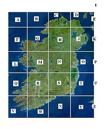
La Grille OSI
Grille de cartographie de l’Irlande

Cet organisme a pris la succession en 1922 de la division irlandaise de l’Ordnance Survey du Royaume-Uni qui existait depuis 1824. Tout son travail prend sa source dans les différentes missions menées entre 1815 et 1845 par des officiers anglais du Royal Engineers et par des membre du service des Mines qui ont à ce moment-là rédigé un ensemble de 6 cartes d’une précision jamais atteinte sur l’île.

En collaboration avec son alter ego en Irlande du Nord, cet organisme est destiné à cartographier à différentes échelles l’ensemble de l’île d’Irlande.

Cartographie

L’Irlande (comme le Royaume-Uni) n’utilise généralement pas les latitudes et les longitudes pour décrire un lieu qui se trouve sur leur territoire national. Ils ont mis en place un système de référence.

L’île d’Irlande est divisée en 20 cases de 100 km de côté, chacune identifiée par une lettre. Chaque case possède une graduation numérique en partant du coin sud ouest. Par exemple G0305 signifie Case G 3 km est, 5 km nord.

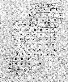
Il existe également des tirages dit 'Discovery Series' de l'OSI. L’île d’Irlande est ainsi divisée en cases de 30km de côté, par 40km en largeur, à l'échelle de 1:50 000 chacune identifiée par un numero (1 à 89). Voir plan, ref: No. 41 ~ Centre de Westmeath.

Lien externe

Ordinance Survey Ireland, Site officiel de l’OSI


Wikimedia Foundation. 2010.

Contenu soumis à la licence CC-BY-SA. Source : Article Ordnance Survey Ireland de Wikipédia en français (auteurs)

Игры ⚽ Нужно решить контрольную?

Regardez d'autres dictionnaires:

  • Ordnance Survey Ireland — (OSi; Irish: Suirbhéireacht Ordanáis Éireann) is the national mapping agency of the Republic of Ireland and, together with the Ordnance Survey of Northern Ireland (O.S.N.I.), succeeded, after 1922, the Irish operations of the United Kingdom… …   Wikipedia

  • Ordnance Survey — Welsh: Arolwg Ordnans Non ministerial government department overview Formed 1791 ( …   Wikipedia

  • Ordnance Survey of Northern Ireland — (OSNI) was the official mapping agency of Northern Ireland. The agency ceased to exist separately on 1 April 2008 when it became part of Land and Property Services Northern Ireland, an executive agency of the Northern Ireland Department of… …   Wikipedia

  • Ordnance Survey — Das Hauptgebäude des Ordnance Survey in Maybush, Southampton Der Ordnance Survey ist eine ausführende Behörde der Regierung des Vereinigten Königreiches. Er ist verantwortlich für die nationale Landesvermessung Großbritanniens[1] und …   Deutsch Wikipedia

  • Ordnance Survey — 50° 55′ 54″ N 1° 27′ 04″ W / 50.9316, 1.4510 …   Wikipédia en Français

  • Ordnance Survey Memoirs of Ireland — is a set of supplementary memoirs that accompanied the first Ordnance Survey of Ireland. History In 1842 the Duke of Wellington, then Prime Minister, authorised the first Ordnance Survey of Ireland. The survey was intended to facilitate a uniform …   Wikipedia

  • ordnance survey map — UK US noun [countable] [singular ordnance survey map plural ordnance survey maps] a very detailed official map of a part of the UK http://www.macmillandictionary.com/med2cd/weblinks/ordnance survey map.htm The …   Useful english dictionary

  • Ordnance survey — Ordnance Ord nance, n. [From OE. ordenance, referring orig. to the bore or size of the cannon. See {Ordinance}.] Heavy weapons of warfare; cannon, or great guns, mortars, and howitzers; artillery; sometimes, a general term for all weapons,… …   The Collaborative International Dictionary of English

  • Ordnance Survey National Grid — For the electricity network, see National Grid (Great Britain). Geodesy Fundamentals …   Wikipedia

  • Ordnance Survey — La Ordnance Survey maps of Great Britain usa la rejilla nacional de Gran Bretaña como referencia de todos los mapas de este país. Ordnance Survey (OS) es una agencia ejecutiva del gobierno del Reino Unido. Es la Agencia Nacional de Mapeado para… …   Wikipedia Español

Share the article and excerpts

Direct link
Do a right-click on the link above
and select “Copy Link”