Narooma
Contenu soumis à la licence CC-BY-SA. Source : Article Narooma de Wikipédia en français (auteurs)
Regardez d'autres dictionnaires:
Narooma — Original name in latin Narooma Name in other language Narooma, Naruma, Noorooma, QRX, Нарума State code AU Continent/City Australia/Sydney longitude 36.22101 latitude 150.13062 altitude 34 Population 2499 Date 2012 02 28 … Cities with a population over 1000 database
Narooma, New South Wales — Narooma New South Wales Bridge at Narooma on the Princes Highway (National Route 1) … Wikipedia
Narooma Palms Holiday Apartments — (Narooma,Австралия) Категория отеля … Каталог отелей
Narooma Motel YHA — (Narooma,Австралия) Категория отеля … Каталог отелей
Narooma Waters Retreat — (Murray Bridge,Австралия) Категория отеля: Адрес: 16 Narooma Way, 5253 Murra … Каталог отелей
Narooma Terrane — The Narooma Accretionary Complex or Narooma Terrane is a geological structural region on the south coast of New South Wales, Australia that is the remains of a subduction zone or an oceanic terrane. It can be found on the surface around Narooma,… … Wikipedia
Narooma — /nəˈrumə/ (say nuh roohmuh) noun a coastal town in south eastern NSW, north of Bega; a popular tourist resort, noted for its big game fishing. {from Noorooma the name of a local cattle station (Australian Aboriginal; Dhurga) …
Court houses in New South Wales — were designed by the Colonial Architect, later known as the Government Architect. Contents 1 Current role 2 History of New South Wales Local Courts 3 Court house buildings of New South Wales … Wikipedia
Lachlan Fold Belt — The Lachlan Fold Belt (LFB) or Lachlan Orogen is a geological subdivision of the east part of Australia. It is a zone of folded and faulted rocks of similar age. It dominates New South Wales and Victoria, also extending into Tasmania, the… … Wikipedia
Montague Island (Australia) — Montague Island Nature Reserve IUCN Category Ia (Strict Nature Reserve) … Wikipedia
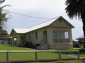
 Le palais de justice de Narooma
 Australie


