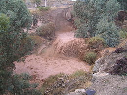
Nahal Harod
- Nahal Harod
-
Le Nahal Harod (נחל חרוד) est un cours d'eau de Galilée, situé aux pieds du Mont Guilboa, et qui longe la vallée de Harod avant de se jeter dans le Jourdain. Sa source porte le nom de Eïn-Jézréel, se trouvant dans la vallée du même nom. Cette source est mentionnée dans la Bible dans le combat entre le roi Saül et les Philistins (livre de Samuel I 29/1).
C'est aux environs de ce cours d'eau que de nombreuses batailles historiques ont eu lieu, telles que le combat relaté par la Bible de Gédéon contre les Madianites et celui de J'aloud entre les Mamelouks et les Mongoles en 1260.
Parmi les principaux affluents de Nahal Harod, on compte le cours d'eau Shézafim, s'écoulant du Mont Moréh et traversant le kibboutz Kfar-Yéhezkel, et le cours d'eau Nourit, qui prend sa source sur le mont Guiborim.
Son tracé est rectiligne jusqu'à la ville de Beït-Shéan, puis devient sinueux. Durant le mandat britannique, sa partie sinueuse a été bordée de vergers et de forêts.
Wikimedia Foundation.
2010.
Contenu soumis à la licence CC-BY-SA. Source : Article Nahal Harod de Wikipédia en français (auteurs)
Regardez d'autres dictionnaires:
Nahal Alexander — Alexander Alexander stream Length 28 miles (45 km) Nahal Alexander (נחל אלכסנדר) is a river that flows from the mountains of Samaria to the … Wikipedia
HUMAN GEOGRAPHY — In respect of human as well as of physical geography, it is convenient to divide the Land of Israel into four major units: 1. the Mediterranean Coastal Plain 2. the hill regions of northern and central Cisjordan (west of the Jordan) 3. the Rift… … Encyclopedia of Judaism
Scythopolis — Tel Beït Shéan 32° 30′ 11″ N 35° 30′ 10″ E / 32.503047, 35.502769 … Wikipédia en Français
Tel Beit-Shean — Tel Beït Shéan 32° 30′ 11″ N 35° 30′ 10″ E / 32.503047, 35.502769 … Wikipédia en Français
Tel Beït-Shéan — 32° 30′ 11″ N 35° 30′ 10″ E / 32.503047, 35.502769 … Wikipédia en Français
Tel beït-shéan — 32° 30′ 11″ N 35° 30′ 10″ E / 32.503047, 35.502769 … Wikipédia en Français
JEZREEL, VALLEY OF — (also known as the Plain of Esdraelon ; (Heb. עֵמֶק יִזְרְעֶאל), Emek Yizre el, named after the city of jezreel ), the largest of the inland valleys of Israel, after the Jordan Valley. It consists of the alluvial plain of the Kishon River,… … Encyclopedia of Judaism
Beit She'an — Beït Shéan Bet Shéan (he) בית שאן – (ar) بيسان … Wikipédia en Français
Beit Shean — Beït Shéan Bet Shéan (he) בית שאן – (ar) بيسان … Wikipédia en Français
Bet-Shean — Beït Shéan Bet Shéan (he) בית שאן – (ar) بيسان … Wikipédia en Français

