Lichk
- Lichk
-
40° 09′ 49″ N 45° 13′ 40″ E / 40.163611, 45.227778
Lichk (en arménien Լիճք « lac » ; anciennement Gyol[2]) est une communauté rurale du marz de Gegharkunik, en Arménie. Fondée en 1830[2], elle compte 5 350 habitants en 2008[3].
Notes et références
- ↑ (hy+en) Central Electoral Commission of the Republic of Armenia. Consulté le 24 janvier 2011.
Pour obtenir la page en anglais, cliquez sur le drapeau arménien en haut à gauche, et sélectionnez « English » ; ensuite, dans le menu vertical de gauche, cliquez sur « Local », sélectionnez le
marz pertinent, puis la dernière élection correspondant à la communauté voulue.
- ↑ a et b (en) Brady Kiesling, Rediscovering Armenia, 2000, p. 45 [lire en ligne (page consultée le 25 mars 2010)] .
- ↑ (en) ArmStat, Marzes of the Republic of Armenia in figures, 2008, « RA Gegharkunik Marz », 2008. Consulté le 6 avril 2009.
Sur les autres projets Wikimedia :
Wikimedia Foundation.
2010.
Contenu soumis à la licence CC-BY-SA. Source : Article Lichk de Wikipédia en français (auteurs)
Regardez d'autres dictionnaires:
Lichk — For the town in Syunik province, see Lichk, Syunik. Infobox Settlement official name = Lichk Լիճք native name = pushpin mapsize =150px subdivision type = Country subdivision name = Armenia subdivision type1 = Province subdivision name1 =… … Wikipedia
Lichk' — Original name in latin Lichk’ Name in other language Gel, Gl, Lichk, Lichk , Lichk’, Личк State code AM Continent/City Asia/Yerevan longitude 40.15933 latitude 45.23467 altitude 1930 Population 4105 Date 2012 01 17 … Cities with a population over 1000 database
Lichk (Syunik) — Pour l’article homonyme, voir Lichk. 39° 03′ 22″ N 46° 10′ 27″ E / … Wikipédia en Français
Lichk, Syunik — Infobox Settlement official name =Lichk Լիճք native name = pushpin mapsize =150px subdivision type = Country subdivision name = Armenia subdivision type1 = Marz (Province) subdivision name1 =Syunik leader title = leader name = established title … Wikipedia
List of municipalities of Armenia — Map of Armenia The Municipalities of Armenia are referred to as communities (համայնքներ hamaynkner, singular համայնք hamaynk ). Each community is self governing and consists of one or more settlements (bnakavayrer, singular bnakavayr).… … Wikipedia
Yerevan — For other uses, see Yerevan (disambiguation). Coordinates: 40°11′00″N 44°31′00″E … Wikipedia
Gavar — Coordinates: 40°21′32″N 45°07′36″E / 40.35889°N 45.12667°E / 40.35889; 45.12667 … Wikipedia
Goris — Գորիս community The city of Goris in 2008 … Wikipedia
Meghri — Մեղրի community … Wikipedia
Artsvashen — For the village in Tartar Rayon, Azerbaijan, see Seysulan. Coordinates: 40°38′N 45°30′E / 40.633°N 45.5°E / 40.633; 45.5 … Wikipedia
 Pour l’article homonyme, voir Lichk (Syunik).
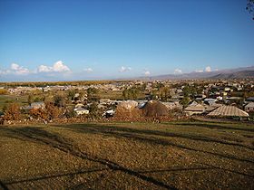
 Arménie


