Laurel (Maryland)

Laurel (Maryland)
Page d'aide sur l'homonymie Pour les articles homonymes, voir Laurel (homonymie).

39° 05′ 54″ N 76° 51′ 33″ W / 39.098333, -76.859167

Laurel
Image illustrative de l'article Laurel (Maryland)
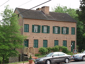
Devise : Progressio Per Populum
Administration
Pays Drapeau des États-Unis États-Unis
État Maryland Maryland
Comté Prince George
Maire Craig A. Moe
Site web Consulter
Historique
Fondation 1870
Démographie
Population (2000) 19 960 hab.
Densité 2 016 hab./km²
Géographie
Coordonnées 39° 05′ 54″ Nord
       76° 51′ 33″ Ouest
/ 39.098333, -76.859167
Altitude 50 m
Superficie totale 9,9 km2
· dont terre 9,8 km2 (98,99 %)
· dont eau 0,1 km2 (1,01 %)
Fuseau horaire EST (UTC-5)
Voir la carte administrative
City locator 14.svg
Voir la carte topographique
City locator 14.svg

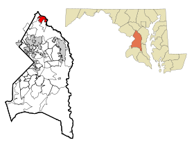
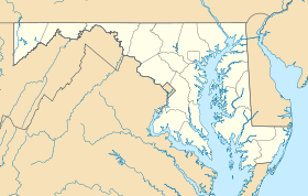
Laurel est une ville américaine incorporée de l’État du Maryland située entre Baltimore et Washington, DC. Bien que la partie incorporée se trouve dans le comté du Prince George, des portions de trois autres comtés – Anne Arundel, Howard et Montgomery – sont considérées comme faisant partie de Laurel. Selon le recensement de 2000, elle compte 19 960 habitants. Sa superficie totale est de 9,9 km² (3,8 mi²). Coordonnées géographiques : 39°5′54″N 76°51′33″O / 39.09833, -76.85917.

Sommaire

Histoire

La ville date de 1870, elle était alors nommée Laurel Factory en raison de la présence d’usines le long de la rivière Patuxent. Son nom fut abrégé en Laurel en 1875.

Le 15 mai 1972, le gouverneur de l’Alabama George Wallace, alors en campagne pour être nommé par le Parti démocrate pour les élections présidentielles, y fut victime d’un attentat perpétré par Arthur Herman Bremer qui le laissa paralysé.

Actualité

Le nom de la ville fut cité lors de l’enquête sur les attentats du 11 septembre 2001. En effet, les kamikazes ayant détourné le vol 77 American Airlines ont séjourné à Laurel et ont utilisé des cybercafés locaux pour contacter les autres groupes djihadistes chargés de détourner les autres vols.

Liens externes

Source


Wikimedia Foundation. 2010.

Contenu soumis à la licence CC-BY-SA. Source : Article Laurel (Maryland) de Wikipédia en français (auteurs)

Игры ⚽ Нужно сделать НИР?

Regardez d'autres dictionnaires:

  • Laurel (Maryland) — Laurel Ciudad de los Estados Unidos Entidad …   Wikipedia Español

  • Laurel, Maryland — Infobox Settlement official name = Laurel, Maryland settlement type = City nickname = motto = Progressio Per Populum (Progress Through People) imagesize = 250px image caption = Laurel Museum, May 12, 2007 image mapsize = 250x200px map caption =… …   Wikipedia

  • Laurel High School (Laurel, Maryland) — Infobox high school name= Laurel High School established = 1899 type = Public comprehensive secondary school principal = Mr. Dwayne Jones enrollment = Approximately 1,990 (2005 06) city = Laurel state = Maryland country = United States of America …   Wikipedia

  • List of mayors of Laurel, Maryland — This is a list of mayors of Laurel, Maryland, a city in the central part of the U.S. state of Maryland.[1][2][3] Before the city s (nonpartisan) office of Mayor was established, a similar role was that of President of the Board of Commissioners.… …   Wikipedia

  • Montpelier Mansion (Laurel, Maryland) — Montpelier U.S. National Register of Historic Places U.S. National Historic Landmark …   Wikipedia

  • South Laurel (Maryland) — South Laurel Lugar designado por el censo de los Estados Unidos …   Wikipedia Español

  • North Laurel (Maryland) — North Laurel CDP de los Estados Unidos …   Wikipedia Español

  • North Laurel, Maryland —   CDP   …   Wikipedia

  • First United Methodist Church (Laurel, Maryland) — Infobox Historic building caption = name = First United Methodist Church location town = Laurel, Maryland location country = US architect = client = engineer = construction start date= completion date = 1884 date demolished = cost = structural… …   Wikipedia

  • South Laurel, Maryland — Infobox Settlement official name = South Laurel, Maryland settlement type = CDP nickname = motto = imagesize = image caption = image imagesize = image caption = image mapsize = 250x200px map caption = Location of South Laurel, Maryland mapsize1 …   Wikipedia

Share the article and excerpts

Direct link
Do a right-click on the link above
and select “Copy Link”