Langisjór
- Langisjór
-
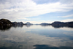
Langisjór est un lac sur les Hautes Terres d'Islande.
Géographie
Sa superficie est d'environ 26 km2[1]. Le lac a une profondeur maximale de 75 mètres[1].
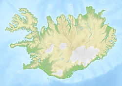
Le lac est situé au bord du glacier Vatnajökull au sud-ouest de l'Islande dans un lieu assez éloigné de la civilisation.
Voir aussi
Lien externe
Notes et références
Wikimedia Foundation.
2010.
Contenu soumis à la licence CC-BY-SA. Source : Article Langisjór de Wikipédia en français (auteurs)
Regardez d'autres dictionnaires:
Langisjor — Langisjór Geographische Lage: Island Daten … Deutsch Wikipedia
Langisjór — Geographische Lage Island Daten Koordinaten … Deutsch Wikipedia
Langisjor — Langisjór Langisjór Administration Pays … Wikipédia en Français
Langisjór — Infobox lake lake name = Langisjór image lake = Langisjor 2006.jpg caption lake = in summer image bathymetry = caption bathymetry = location = coords = coord|64|11|N|18|15|W|region:IS type:waterbody|display=inline,title type = inflow = outflow =… … Wikipedia
Langisjór — Sp Láungisjouras Ap Langisjór L ež. Islandijoje … Pasaulio vietovardžiai. Internetinė duomenų bazė
Лангисьоур — Langisjór Координаты: Координаты … Википедия
Skaftarhreppur — Skaftárhreppur Basisdaten Staat: Island Region: Suðurland Wahlkreis: Suðurkjördæmi Sýsla … Deutsch Wikipedia
List of lakes in Iceland — Lakes of Iceland (partially indicating surface or depth)Iceland has about 67 lakes. With a few exceptions, only lakes over 2.5 km² (1 sq mi) in size are included. The figures for many of the smaller lakes are unreliable. Also, some larger lakes… … Wikipedia
Öskjuvatn — Coordinates … Wikipedia
Mývatn — Coordinates 65°36′N 17°00′W / … Wikipedia

 Islande

