Krimpenerwaard
- Krimpenerwaard
-
51°58′56″N 4°46′54″E / 51.98222, 4.78167
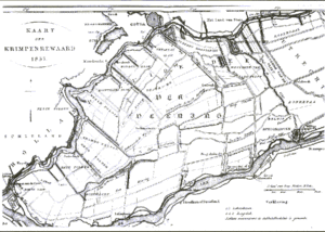
Le Krimpenerwaard est un waard néerlandais, c'est-à-dire une région ou un territoire entièrement entouré de cours d'eau, situé dans la partie orientale de la province de la Hollande-Méridionale.
Il est entouré par le Lek au sud, le Hollandse IJssel au nord et le Vlist à l'est. Il tire son nom des deux localités de Krimpen (Krimpen aan den IJssel et Krimpen aan de Lek) situées à l'extrémité ouest de la région. En outre, la région comporte notamment les villes et villages de Schoonhoven, Bergambacht, Stolwijk, Ammerstol, Haastrecht, Berkenwoude, Lekkerkerk, Vlist, Gouderak et Ouderkerk aan den IJssel. La superficie du Krimpenerwaard s'élève à environ 13 500 hectares. La hauteur moyenne de la région est de -2 m en dessous du niveau de la mer (-2 m NAP).
À l'est se trouve le Lopikerwaard, au sud l'Alblasserwaard et au nord-ouest le Zuidplaspolder.
La région est mentionnée dès 944.
Source
Lien externe
Wikimedia Foundation.
2010.
Contenu soumis à la licence CC-BY-SA. Source : Article Krimpenerwaard de Wikipédia en français (auteurs)
Regardez d'autres dictionnaires:
Krimpenerwaard — The Krimpenerwaard, located in the province of South Holland in the Netherlands, is the rural area just south of Gouda and just east of the Rotterdam conurbation. It is borderd on the north by the river Hollandse IJssel, on the south by the river … Wikipedia
Lekkerkerk — is a town and former municipality on the Lek River in the municipality Nederlek, province South Holland, the Netherlands. Since 1 January 1985 Lekkerkerk no longer is an independent municipality.Lekkerkerk is mostly an agricultural community with … Wikipedia
Ouderkerk aan den IJssel — village View of Ouderkerk aan den IJssel … Wikipedia
South Holland — Infobox Dutch Province ename = Province of South Holland dname = Provincie Zuid Holland common name = South Holland location Clicksensitive map of provinces of the Netherlands|province=South Holland capital = The Hague largest city = Rotterdam… … Wikipedia
Hollandse IJssel — IJssel hollandais Pour les articles homonymes, voir IJssel (homonymie). IJssel hollandais ou Hollandse IJssel … Wikipédia en Français
IJssel Hollandais — Pour les articles homonymes, voir IJssel (homonymie). IJssel hollandais ou Hollandse IJssel … Wikipédia en Français
IJssel hollandais — 51° 54′ 29″ N 4° 33′ 40″ E / 51.9081, 4.56111 … Wikipédia en Français
Ijssel hollandais — Pour les articles homonymes, voir IJssel (homonymie). IJssel hollandais ou Hollandse IJssel … Wikipédia en Français
Krimpen aan den IJssel — Infobox Settlement official name = Krimpen aan den IJssel flag size = 120x100px image shield = Wapen Krimpen aan den IJssel.svg shield size = 120x100px mapsize = 280px subdivision type = Country subdivision name = Netherlands subdivision type1 =… … Wikipedia
Groene Hart — The Groene Hart (English: Green Heart) is a relatively thinly populated area in the Dutch Randstad. The major Dutch cities of Rotterdam, Den Haag, Leiden, Haarlem, Amsterdam and Utrecht lie around this area. Other cities inside the Groene Hart… … Wikipedia


