Kolderwâlde

Kolderwâlde

Kolderwolde

52°53′50″N 5°30′36″E / 52.89722, 5.51

Kolderwolde
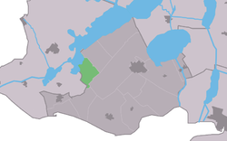
Map NL Gaasterlân Sleat Kolderwâlde.png
Vue de la localité sur la carte des Pays-Bas

Pays Pays-Bas Pays-Bas
Commune Gaasterlân-Sleat
Province Frise
Nombre d'habitants 67 (2008)
Code postal 8583

Kolderwolde est un village situé dans la commune néerlandaise de Gaasterlân-Sleat, dans la province de la Frise. Son nom en frison est Kolderwâlde. Le 1er janvier 2008, le village comptait 67 habitants.

  • Portail des Pays-Bas Portail des Pays-Bas
Ce document provient de « Kolderwolde ».

Wikimedia Foundation. 2010.

Contenu soumis à la licence CC-BY-SA. Source : Article Kolderwâlde de Wikipédia en français (auteurs)

Игры ⚽ Поможем написать реферат

Regardez d'autres dictionnaires:

  • Kolderwolde — Infobox Settlement official name = Kolderwolde mapsize = 280px subdivision type = Country subdivision name = flagicon|Netherlands Netherlands subdivision type1 = Province subdivision name1 = flagicon|Friesland Friesland settlement type = Village… …   Wikipedia

  • Gaasterlan-Sleat — Gaasterlân Sleat Gaasterlân Sleat …   Wikipédia en Français

  • Gaasterland — Gaasterlân Sleat Gaasterlân Sleat …   Wikipédia en Français

  • Gaasterland-Sloten — Gaasterlân Sleat Gaasterlân Sleat …   Wikipédia en Français

  • Gaasterlân-Sleat — Héraldique …   Wikipédia en Français

  • Gaasterlân-sleat — Gaasterlân Sleat …   Wikipédia en Français

  • Kolderwolde — 52°53′50″N 5°30′36″E / 52.89722, 5.51 …   Wikipédia en Français

Share the article and excerpts

Direct link
Do a right-click on the link above
and select “Copy Link”