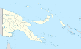
Kokopo
- Kokopo
-
4° 21′ 00″ S 152° 16′ 01″ E / -4.35, 152.267
Kokopo est la capitale provinciale de la Nouvelle-Bretagne orientale. La capitale a été déplacée de Rabaul quand les volcans Tavurvur et Vulcan ont fait éruption en 1994.
Histoire
L'ancien nom allemand était Herbertshöhe entre 1884 et 1914, lorsqu'elle était capitale de l'administration coloniale de la Nouvelle-Poméranie (Neu-Pommern).
Wikimedia Foundation.
2010.
Contenu soumis à la licence CC-BY-SA. Source : Article Kokopo de Wikipédia en français (auteurs)
Regardez d'autres dictionnaires:
Kokopo — Staat: Papua Neuguinea … Deutsch Wikipedia
Kokopo — Infobox PNG Place type = city name = Kokopo othername = province = enb llg = Vunamami/Kokopo lang = English, Tok Pisin, Kuanua langarea = Kuanua dot x = 183 dot y = 46 caption = Beach at Kokopo, looking towards the Rabaul volcanoes pop = 20,262… … Wikipedia
Kokopo — Original name in latin Kokopo Name in other language Kokopo State code PG Continent/City Pacific/Port Moresby longitude 4.35202 latitude 152.26327 altitude 100 Population 26273 Date 2012 01 16 … Cities with a population over 1000 database
Kokopo Beach Bungalow Resort — (Кокопо,Папуа Новая Гвинея) Категория отеля: 4 звездочный отель Адрес … Каталог отелей
Kokopo District — Admin ASC 2 Code Orig. name Kokopo District Country and Admin Code PG.10.2093683 PG … World countries Adminstrative division ASC I-II
Kokopo — Herbertshöhe (veraltet, bis 1918) … Universal-Lexikon
Herbertshöhe — Kokopo … Universal-Lexikon
Herbertshöhe — DMS … Deutsch Wikipedia
East New Britain Province — East New Britain Geographie Staat: Papua Neuguinea Gewässer: Pazifischer Ozean … Deutsch Wikipedia
East New Britain — Lage der East New Britain Province in Papua Neuguinea East New Britain ist eine der 19 Provinzen von Papua Neuguinea. Es umfasst die Osthälfte der Insel Neubritannien sowie die kleinen Duke of York Inseln (60 km²) im Saint George’s Channel… … Deutsch Wikipedia
 Papouasie-Nouvelle-Guinée
