Kennington

Kennington

51° 28′ 53″ N 0° 07′ 11″ W / 51.4813, -0.1197

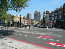
Rues de Kennington (2006)

Kennington est un quartier du Sud de Londres, situé dans le district londonien de Lambeth. C'est une banlieue résidentielle très ouvrière et on y trouve l'Ovale, célèbre stade de cricket.

En 1337 Édouard III a donné le manoir de Kennington à son fils aîné Édouard, le « Prince Noir », qui a construit alors un grand palais royal entre ce qui est maintenant Black Prince Road et Sancroft Street. Geoffrey Chaucer a été employé à Kennington comme secrétaire des travaux en 1389, recevant pour cette tâche 2 shillings. Le domaine de Kennington appartient toujours aux fils aînés des souverains (Princes de Galles et ducs de Cornouaille).

Le Parc de Kennington (créé par l'architecte victorien James Pennethorne) et le cimetière Saint-Marc occupent maintenant l'emplacement du Common, le pré communal de Kennington. En 1746 le Gibet du Comté de Surrey, à l'extrémité sud du Common, a été utilisé pour exécuter neuf chefs de la rébellion jacobite de 1745. Le Common a été aussi l'endroit où les chartistes se sont rassemblés pour leur plus grande manifestation en 1848.

Kennington Park Road et Clapham Road constituent une route longue et droite qui suit la vieille route romaine. Elle va du Pont romain de Londres à Chichester en passant par le seuil des collines du Nord à Box Hill, près de Dorking. Une autre route romaine bifurquait du côté opposé à Kennington Road et descendait par ce qui est maintenant Kennington Park jusqu'à Brixton Road. À travers les Collines du Nord elle conduisait à Hassocks près de Caterham, juste au nord des Collines du Sud.

Localités les plus proches :

Stations de métro les plus proches :

Il y a deux villages en Angleterre qui portent eux aussi ce nom :

  • Kennington : un village dans le Kent
  • Kennington : un village au sud d'Oxford

Références


Wikimedia Foundation. 2010.

Contenu soumis à la licence CC-BY-SA. Source : Article Kennington de Wikipédia en français (auteurs)

Игры ⚽ Поможем написать курсовую

Regardez d'autres dictionnaires:

  • Kennington — ist der Name folgender geographischer Objekte: Kennington (London), zum Borough of Lambeth gehörig, Stadtteil von London, England Kennington (Oxfordshire): ein Dort im Süden Oxfordshires, England Kennington (Kent): ein Dorf in Kent, England… …   Deutsch Wikipedia

  • Kennington — Kennington, ein Stadtteil im Süden Londons, 2 km von der Westminsterbrücke, zum Verwaltungsbezirk Lambeth gehörig, mit Park, der 1848 Schauplatz der Chartistendemonstration war. Als parlamentarischer Wahlbezirk hat es (1901) 78,313 Einw …   Meyers Großes Konversations-Lexikon

  • Kennington — infobox UK place country = England map type = Greater London region= London population= official name= Kennington london borough= Lambeth constituency westminster= Vauxhall post town= LONDON postcode area= SE postcode district= SE11 dial code=… …   Wikipedia

  • Kennington — This famous surname recorded in the modern spellings of Kennington, Kenington, and Kensington, is of Olde English pre 7th century origins. It derives from one of probably four such places in Berkshire, Kent, Middlesex, and Surrey, all of whom… …   Surnames reference

  • Kennington — 1 Original name in latin Kennington Name in other language State code GB Continent/City Europe/London longitude 51.1674 latitude 0.88491 altitude 48 Population 4178 Date 2010 05 24 2 Original name in latin Kennington Name in other language State… …   Cities with a population over 1000 database

  • Kennington Park — is in Kennington, London, England, in London SE11, and lies between Kennington Park Road and St Agnes Place. It was opened in 1854. Previously the site had been Kennington Common. This is where the Chartists gathered for their biggest monster… …   Wikipedia

  • Kennington tube station — is a London Underground station in Kennington, on both the Charing Cross and Bank branches of the Northern Line. Its neighbours to the north are Waterloo on the Charing Cross branch and Elephant Castle on the Bank branch; the next station to the… …   Wikipedia

  • Kennington Road — is a long straight road, approximately a mile in length, in the London Borough of Lambeth, SE1 running south from Westminster Bridge Road (at the junction with Baylis Road to the north east) to Kennington Park Road. The road is designated as the… …   Wikipedia

  • Kennington, Oxfordshire — Kennington is a village and civil parish in the Vale of White Horse District Council area of the English county of Oxfordshire (though it was in Berkshire until 1974), just to the south of Oxford. It sits in a narrow stretch of land between the… …   Wikipedia

  • Kennington Park Road — is a main road in south London, England, and is part of the A3 trunk road. It runs from Newington Butts at its Y junction with Kennington Lane, south west to the Oval, where the A3 continues as Clapham Road, towards Stockwell. At this crossroads… …   Wikipedia

Share the article and excerpts

Direct link
Do a right-click on the link above
and select “Copy Link”