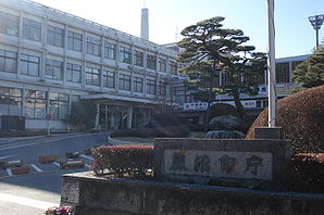
Kanuma
- Kanuma
-
36°34′N 139°45′E / 36.567, 139.75
Kanuma (鹿沼市, Kanuma-shi?) est une ville située dans la préfecture de Tochigi, Japon.
Au 1er mars 2010, la ville avait une population estimée à 102 825 habitants et une densité de 210 personnes/km2. Elle s'étend sur 490,62 km2.
La ville a été fondé le 10 octobre 1948.
Elle a hébergé une partie de l'enfance d'Hayao Miyazaki.
Les symboles municipaux sont le cèdre du Japon et le Rhododendron indicum.
Kanuma est desservie par les routes :
- 国道121号 (Route nationale 121)
- 国道293号 (Route nationale 293)
- 国道352号 (Route nationale 352)
Jumelages
Liens externes
Sur les autres projets Wikimedia :
Wikimedia Foundation.
2010.
Contenu soumis à la licence CC-BY-SA. Source : Article Kanuma de Wikipédia en français (auteurs)
Regardez d'autres dictionnaires:
Kanuma — shi 鹿沼市 … Deutsch Wikipedia
Kanuma — ▪ Japan city, Tochigi ken (prefecture), Honshu, Japan. It lies at the eastern foot of the Ashio Highlands. The central part of the city was a post town during the Tokugawa period (1603–1867); it later developed as a market for hemp seed.… … Universalium
Kanuma — Original name in latin Kanuma Name in other language Kamima, Kanuma, lu zhao shi, Канума State code JP Continent/City Asia/Tokyo longitude 36.55 latitude 139.73333 altitude 162 Population 94903 Date 2012 01 19 … Cities with a population over 1000 database
Kanuma (Gambia) — Kanuma 13.500482201111 16.504518128056{{{elevation save}}}Koordinaten … Deutsch Wikipedia
Kanuma (Tochigi) — 鹿沼市 Kanuma … Wikipedia Español
Kanuma, Tochigi — Infobox City Japan Name= Kanuma JapaneseName= 鹿沼市 Map Region=Kantō Prefecture=Tochigi District= Area km2=490.62 PopDate=May 2008 Population=103,373 Density km2=211 Coords= LatitudeDegrees= 36 LatitudeMinutes= 34 LatitudeSeconds= LongtitudeDegrees … Wikipedia
Kanuma-shi — Admin ASC 2 Code Orig. name Kanuma shi Country and Admin Code JP.38.1860097 JP … World countries Adminstrative division ASC I-II
Chisun Inn Utsunomiya Kanuma — (Уцуномия,Япония) Категория отеля: 3 звездочный отель Адрес: 320 0851 Тотиги, Уцуномия, Tsurutacho 3020 1 , Япония … Каталог отелей
Liste des films Roman Porno — Nikkatsu a désigné sous l appellation de Roman Porno l ensemble des pinku eiga ou films roses ou encore films érotiques que ses studios ont produit et commercialisés de novembre 1971 à mai 1988. Ces films, extrêmement connus et appréciés ont… … Wikipédia en Français
Sankranthi — Sankranthi, or Sankranti (Sanskrit: मकर संक्रान्ति , is a festival that signifies the beginning of the harvest season for the farmers of Indian Sub Continent. This is a harvest festival celebrated not only all over India but other South East… … Wikipedia


