Inchgarvie
- Inchgarvie
-
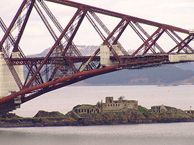
Inchgarvie est une petite île du Firth of Forth, à l'est de l'Écosse. Elle est située près du Forth Bridge. Elle fut fortifiée durant la Seconde Guerre mondiale. Des rumeurs courent selon lesquelles Inchgarvie est peuplée de rats géants.
Son nom vient de l'écossais Innis Garbhach (« île âpre »).
Voir aussi
Wikimedia Foundation.
2010.
Contenu soumis à la licence CC-BY-SA. Source : Article Inchgarvie de Wikipédia en français (auteurs)
Regardez d'autres dictionnaires:
Inchgarvie — (occasionally Inch Garvie ) is a small island in the Firth of Forth. Presently uninhabited, Inchgarvie has seen various inhabitants over the years, and is known to have been inhabited at least as early as the late 15th century.The name comes from … Wikipedia
Inchgarvie — INCHGARVIE, an isle, in the parish of Inverkeithing, county of Fife. This is a small islet in the Frith of Forth, about half a mile south of Queensferry, in the parish of Inverkeithing, and double this distance from Queensferry, on the… … A Topographical dictionary of Scotland
Inchkeith — Infobox Scottish island | latitude=56 longitude= 3.1 GridReference= NT293826 celtic name=Innis Cheith norse name= meaning of name=Island of Keith, or the Wood area= c.20 ha area rank= highest elevation= 60 m Population=0 population rank= main… … Wikipedia
Organisation défensive du Royaume-Uni pendant la Seconde Guerre mondiale — Gros plan sur l embrasure d un emplacement de tir abrité. L organisation défensive du Royaume Uni durant la Seconde Guerre mondiale a entraîné une mobilisation des militaires et des civils sur une très grande échelle en réponse à la menace d… … Wikipédia en Français
Список островов Шотландии — Карта Внешних и Внутренних Гебрид Этот список содержит перечисление морских и пресноводных островов Шотландии (континентальная часть которой является частью острова Великобритания). Помимо того, в список включены связанные с рас … Википедия
Forth Railway Bridge — Infobox Bridge bridge name= Forth Bridge official name= carries=Rail traffic crosses=Firth of Forth locale=Edinburgh, Inchgarvie and Fife, Scotland maint=Balfour Beatty under contract to Network Rail id= design=Cantilever bridge mainspan=2 of 521 … Wikipedia
British anti-invasion preparations of World War II — entailed a large scale division of military and civilian mobilization in response to the threat of invasion by German armed forces in 1940 and 1941. The army needed to recover from the defeat of the British Expeditionary Force in France, and 1.5… … Wikipedia
Islands of the Forth — The Islands of the Firth of Forth are a minor island group, lying between Fife and the Lothians, in east Scotland. There are few islands off eastern Scotland, and this group comprises the majority.They include:* Bass Rock * Craigleith *… … Wikipedia
Firth — is the Lowland Scots word used to denote various coastal waters in Scotland. It is usually a large sea bay, which may be part of an estuary, or just an inlet, or even a strait. It is cognate to fjord (both from Proto Germanic *ferþuz) which has a … Wikipedia
Firth of Forth — The Firth of Forth (Scottish Gaelic: Linne Foirthe ) is the estuary or firth of Scotland s River Forth, where it flows into the North Sea between Fife to the north, and West Lothian, the City of Edinburgh, and East Lothian to the south.Geography… … Wikipedia
 Royaume-Uni
 Royaume-Uni

