Gusici
- Gusici
-
Gusići
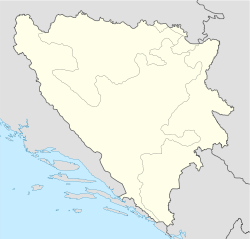
Gusići (en serbe cyrillique : Гусићи) est un village de Bosnie-Herzégovine. Il est situé dans la municipalité de Goražde et dans le canton du Podrinje bosnien, Fédération de Bosnie-et-Herzégovine. Au recensement de 1991, il comptait 58 habitants, dont une majorité de Musulmans (Bosniaques)[1].
Démographie
Répartition de la population (1991)
Notes et références
- ↑ a et b (bs)(hr)(sr) Livre : Composition nationale de la population - Résultats de la République par municipalités et localités 1991, Bulletin statistique n°234, Publication de l'Institut national de statistique de Bosnie-Herzégovine, Sarajevo.
Voir aussi
Articles connexes
Liens externes
 Portail de la Bosnie-Herzégovine
Catégorie : Localité de la Fédération de Bosnie-et-Herzégovine
Wikimedia Foundation.
2010.
Contenu soumis à la licence CC-BY-SA. Source : Article Gusici de Wikipédia en français (auteurs)
Regardez d'autres dictionnaires:
Gusići — 43° 41′ 32″ N 18° 46′ 30″ E / 43.6922, 18.7750 … Wikipédia en Français
Gorazde (Bosnie-Herzegovine) — Goražde (Bosnie Herzégovine) Pour les articles homonymes, voir Goražde. Goražde Горажде [[Image:|100px|center|Blason]] [[Image:|100px|center|Drapeau]] … Wikipédia en Français
Goražde (Bosnie-Herzégovine) — Pour les articles homonymes, voir Goražde. 43° 40′ 01″ N 18° 58′ 35″ E … Wikipédia en Français
Lika — is a mountainous region in central Croatia, roughly bound by the Velebit mountain from the southwest and the Plješevica mountain from the northeast. On the north west end Lika is bounded by Ogulin Plaški basin, and on the south east by the… … Wikipedia
History of Dalmatia — This article is part of a series Antiquity … Wikipedia
Pavao Ritter Vitezović — (January 7, 1652 – January 20, 1713) was a noted Croatian writer, historian, linguist and publisher.Pavao Ritter Vitezović was born in Senj to a family of a frontier soldier. His father was descended from a German immigrant from Alsace, and his… … Wikipedia
List of settlements in Bosnia and Herzegovina — This is a complete list of settlements in Bosnia and Herzegovina, as recorded by 1991 census, sorted by municipalities. Town of Sarajevo = Sarajevo Centar = • Mrkovići • Nahorevo• Poljine• Radava• Sarajevo (part of settlement)• Vića Sarajevo… … Wikipedia
List of settlements in the Federation of Bosnia and Herzegovina/G — Gabela Čapljina Herzegovina Neretva Canton Gaćice Vitez Central Bosnia Canton Gaj Goražde Bosnian Podrinje Canton Gaj Uskoplje Central Bosnia Canton Gajevi Ilijaš Sarajevo Canton Gajine Ilijaš Sarajevo Canton Gakići Konjic Herzegovina Neretva… … Wikipedia
Kupres — Купрес … Deutsch Wikipedia
Ahmovici — Ahmovići Ahmovići Ахмовићи [[Image:|100px|center|Blason]] [[Image:|100px|center|Drapeau]] Blason Drapeau … Wikipédia en Français

 Bosnie-Herzégovine