Grey District
- Grey District
-
District de Grey

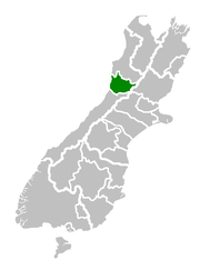
Localisation du district sur une carte de l'
île du Sud
Le district de Grey est situé dans la région de West Coast, dans l'île du Sud de la Nouvelle-Zélande.
S'étendant sur 3 516,48 km2, il inclut les villes de Greymouth, Runanga, Blackball, Cobden et les villages sur les rives du fleuve Grey.
Le recensement de 2006 y a compté 13 221 habitants, dont 3 600 à Greymouth, 1 221 à Runanga, 1 707 à Cobden et 330 à Blackball. Environ 8 % de la population se dit d'origine maori.
Sources
- (en) Cet article est partiellement ou en totalité issu d’une traduction de l’article de Wikipédia en anglais intitulé « Grey District ».
 Portail de la Nouvelle-Zélande
Catégories : Autorité territoriale de Nouvelle-Zélande | West Coast
Wikimedia Foundation.
2010.
Contenu soumis à la licence CC-BY-SA. Source : Article Grey District de Wikipédia en français (auteurs)
Regardez d'autres dictionnaires:
Grey District — It has a land area of 3,516.48 km² (1,357.72 sq mi). The seat of the council is at Greymouth, where 27% of the district s population live.PopulationThe district has a population of 13,221 at the 2006 census, of whom 8% are Maori. Of the total… … Wikipedia
Grey District — Admin ASC 2 Code Orig. name Grey District Country and Admin Code NZ.G3.056 NZ … World countries Adminstrative division ASC I-II
Clarke River (Grey District) — Clarke River Mouth Grey River Basin countries New Zealand Length 12 kilometres (7.5 mi) For other rivers with this name, see Clarke River. The Clarke River is a river in the Grey District, one of three Clarke rivers in the South island of… … Wikipedia
Grey (disambiguation) — Grey may refer to many different things: * Grey, or gray, a neutral color * Scots Greys, a historic military unit * Grey Global Group, , an advertising agency founded 1917 * Greys, in UFOlogy, a type of alien entityPlaces* Grey County, Ontario,… … Wikipedia
District Health Board — District Health Boards (DHBs) in New Zealand are organisations established by the New Zealand Public Health and Disability Act 2000, responsible for ensuring the provision of health and disability services to populations within a defined… … Wikipedia
Grey-Distrikt — Grey District Council Karte Basisdaten Region … Deutsch Wikipedia
District de Grey — 42° 32′ 46″ S 171° 36′ 22″ E / 42.546, 171.606 … Wikipédia en Français
Grey North — was a federal electoral district represented in the Canadian House of Commons from 1867 to 1968. It was located in the province of Ontario. It was created by the British North America Act of 1867, which divided the County of Grey into two ridings … Wikipedia
Grey East — was a federal electoral district represented in the Canadian House of Commons from 1872 to 1917. It was located in the province of Ontario. This riding was created in 1872 from parts of Grey North and Grey South ridings. In 1872, the County of… … Wikipedia
Grey Southeast — was a federal electoral district represented in the Canadian House of Commons from 1917 to 1935. It was located in the province of Ontario. This riding was created in 1914 from parts of Grey East and Grey South ridings when the county of Grey was … Wikipedia


