Gawler Ranges
- Gawler Ranges
-
Chaîne Gawler
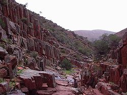
Les tuyaux d'orgues dans la chaîne Gawler
La chaîne Gawler ("The Gawler Ranges") est une chaîne de montagnes de l'Australie méridionale au nord de la péninsule d'Eyre que la route Eyre Highway contourne par le sud. Elle mesure environ 160 kilomètres de long pour un point culminant à 470 mètres. Les principaux sommets sont Mount Granite, Mount Centre, Mount Fairwiew, Mount Double.
La chaîne a été ainsi appelée par l'explorateur Edward John Eyre en l'honneur du gouverneur de l'Australie méridionale George Gawler en 1839 lors d'une de ses premières expéditions dans la région avant sa première traversée de la plaine de Nullarbor.
Le craton Gawler auquel appartient la chaîne de montagnes est riche en ressources minérales mais leur découverte est trop récente pour qu'elles puissent être en pleines exploitations.
Le parc national de la chaîne Gawler ("The Gawler Ranges National Park") et la "Gawler Ranges Conservation Reserve" sont situées au nord de Wudinna.
 Portail de l’Australie
 Portail de la montagne
Catégories : Montagne d'Australie | Massif de montagne d'Océanie
Wikimedia Foundation.
2010.
Contenu soumis à la licence CC-BY-SA. Source : Article Gawler Ranges de Wikipédia en français (auteurs)
Regardez d'autres dictionnaires:
Gawler Ranges — Basaltsäulen in den Gawler Ranges Die Gawler Ranges, eine Berglandschaft Australiens, liegt im Gawler Ranges Nationalpark in South Australia 350 km nordwestlich von Adelaide. Es handelt sich um eine der ältesten vulkanischen Landschaften der Erde … Deutsch Wikipedia
Gawler Ranges — The Gawler Ranges are a range of mountains in South Australia to the north of Eyre Peninsula. The Eyre Highway skirts the south of the ranges. The ranges were named by Edward John Eyre after the Governor of South Australia, George Gawler in 1839 … Wikipedia
Gawler-Ranges-Nationalpark — Gawler Ranges National Park Kolay Mirica Falls … Deutsch Wikipedia
Gawler Ranges National Park — Infobox protected area of Australia | name = Gawler Ranges National Park iucn category = II caption = locator x = 153 locator y = 161 nearest town or city = Wudinna coordinates = coord|32|33|14|S|135|27|50|E| area = 1,663.03 km² established = 15… … Wikipedia
Gawler Ranges — ▪ mountains, South Australia, Australia mountains and hills in South Australia, extending 100 miles (160 km) east west across the northern part of Eyre Peninsula, south of Lake Gairdner; they rise in the west as high as 1,550 feet (475… … Universalium
Gawler Ranges — /gɔlə ˈreɪndʒəz/ (say gawluh raynjuhz) plural noun a series of hills in southern SA, south of Lake Gairdner and north of Eyre Peninsula. Highest peak, Scrubby Peak, 472 m. {named after G Gawler1} …
Gawler Ranges National Park — noun a national park in southern SA, north of the Eyre Peninsula, proclaimed in 2002; red volcanic rock and mallee wilderness. 166 000 ha …
Gawler craton — The Gawler Craton covers approximately 440,000 square kilometres of central South Australia. Its Precambrian crystalline basement crustal block was cratonised ca. 1550 1450 Ma. Prior to 1550 Ma the craton comprised a number of active Proterozoic… … Wikipedia
Gawler — ▪ South Australia, Australia town, South Australia, northeast of Adelaide. It lies at the confluence of the North and South Para rivers (which there form the Gawler River), at the western foot of the Mt. Lofty Ranges. Surveyed in 1839, it… … Universalium
Chaîne Gawler — 32°32′S 135°22′E / 32.533, 135.367 … Wikipédia en Français
 Australie


