Fort Cobb

Fort Cobb
Page d'aide sur l'homonymie Pour les articles homonymes, voir Cobb.

35° 05′ 58″ N 98° 26′ 19″ W / 35.099444, -98.438611

Fort Cobb
Administration
Pays Drapeau des États-Unis États-Unis
État Oklahoma Oklahoma
Comté Caddo
Démographie
Population (2000) 667 hab.
Densité 513 hab./km²
Géographie
Coordonnées 35° 05′ 58″ Nord
       98° 26′ 19″ Ouest
/ 35.099444, -98.438611
Superficie totale 1,3 km2
· dont terre 1,3 km2 (100 %)
· dont eau 0 km2 (0 %)
Fuseau horaire
Voir la carte administrative
City locator 14.svg
Voir la carte topographique
City locator 14.svg

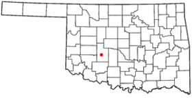
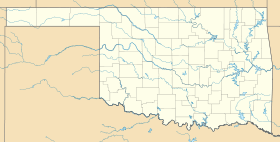
Fort Cobb est une localité du comté de Caddo en Oklahoma aux États-Unis, elle comptait 667 habitants en 2000.

Histoire

Fort Cobb était un poste de l'US Army établi sur la frontier de l'Indian Territory le 1er octobre 1859. Lors de la guerre de Sécession, il fut occupé à tour de rôle par les troupes de l'Union et de la Confédération. Il fut le quartier général du général Custer du 18 décembre 1869 au 6 janvier 1869, lors des guerres indiennes. Le fort fut démilitarisé peu après, mais la localité qui subsista lui doit son nom.

Bibliographie

  • A history of Fort Cobb ; Muriel H Wright; 1957. (OCLC 8404632)
  • The removal of the Texas Indians and the founding of Fort Cobb: Lieutenant William E. Burnet letters ; William E Burnet; David Gouverneur Burnet; Raymond Estep; Oklahoma City, 1961. (OCLC 6389880)

Lien externe


Wikimedia Foundation. 2010.

Contenu soumis à la licence CC-BY-SA. Source : Article Fort Cobb de Wikipédia en français (auteurs)

Игры ⚽ Нужно сделать НИР?

Regardez d'autres dictionnaires:

  • Fort Cobb — Fort Cobb, OK U.S. town in Oklahoma Population (2000): 667 Housing Units (2000): 317 Land area (2000): 0.510277 sq. miles (1.321611 sq. km) Water area (2000): 0.000000 sq. miles (0.000000 sq. km) Total area (2000): 0.510277 sq. miles (1.321611 sq …   StarDict's U.S. Gazetteer Places

  • Fort Cobb, OK — U.S. town in Oklahoma Population (2000): 667 Housing Units (2000): 317 Land area (2000): 0.510277 sq. miles (1.321611 sq. km) Water area (2000): 0.000000 sq. miles (0.000000 sq. km) Total area (2000): 0.510277 sq. miles (1.321611 sq. km) FIPS… …   StarDict's U.S. Gazetteer Places

  • Fort Cobb Reservoir — Infobox lake lake name = Fort Cobb Reservoir image lake = Fortcobblake 1.jpg caption lake = image bathymetry = caption bathymetry = location = Caddo County, Oklahoma coords = type = reservoir inflow = Cobb Creek, Lake Creek outflow = catchment =… …   Wikipedia

  • Fort Cobb, Oklahoma — Infobox Settlement official name = Fort Cobb, Oklahoma settlement type = Town nickname = motto = imagesize = image caption = image mapsize = 250px map caption = Location of Fort Cobb, Oklahoma mapsize1 = map caption1 = subdivision type = Country… …   Wikipedia

  • Fort Cobb Reservoir — Sp Fòrt Kòbo tvenkinỹs Ap Fort Cobb Reservoir L JAV (Oklahoma) …   Pasaulio vietovardžiai. Internetinė duomenų bazė

  • Cobb — Cette page d’homonymie répertorie les différents sujets et articles partageant un même nom. Cobb peut désigner : Patronyme Cobb est un nom de famille notamment porté par : David Cobb (né en 1963), homme politique américain ; Edmund …   Wikipédia en Français

  • Fort Kobo tvenkinys — Sp Fòrt Kòbo tvenkinỹs Ap Fort Cobb Reservoir L JAV (Oklahoma) …   Pasaulio vietovardžiai. Internetinė duomenų bazė

  • Cobb County Parks, Recreation and Cultural Affairs Department — Cobb County Parks, Recreation, and Cultural Affairs Department Seal of the Cobb County PRC Department overview Formed 1966 Headquarters 1792 County Services Pkwy Marietta, GA 30008 …   Wikipedia

  • Cobb Point Bar Light — 1912 photograph of Cobb Point Bar Light (USCG) Location off Cobb Island in the Potomac River at the mouth of the Wicomico River Coordinates …   Wikipedia

  • Fort Niagara — Youngstown, New York Fort Niagara 1728 Type Trading Post …   Wikipedia

Share the article and excerpts

Direct link
Do a right-click on the link above
and select “Copy Link”