Ermin Street
- Ermin Street
-
51° 37′ 39″ N 1° 49′ 12″ W / 51.62739, -1.81987

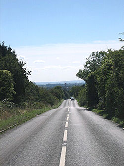
Ermin Street près de Cirencester.
Ermin Street ou Ermin Way est une voie romaine du Royaume-Uni, longue de 77 km. Elle relie Gloucester à la ville romaine de Calleva Atrebatum (Silchester), en passant par Corinium (Cirencester) où elle rejoint les voies de Fosse Way et Akeman Street.
Aujourd'hui, Ermin Street est recouvertes par les routes A417, A419 et B4000.
Bibliographie
- Thomas Codrington, Roman Roads in Britain, Londres, 1903
- Ivan D. Margary, Roman Roads in Britain, Londres, 1967
Wikimedia Foundation.
2010.
Contenu soumis à la licence CC-BY-SA. Source : Article Ermin Street de Wikipédia en français (auteurs)
Regardez d'autres dictionnaires:
Ermin Street — or Ermin Way (not to be confused with Ermine Street, which is further east) is one of the great Roman roads of Britain. It runs from Gloucester (Glevum) via Cirencester (Corinium) to Silchester (Calleva Atrebatum). Much of it is now covered by… … Wikipedia
Ermin Way — Ermin Street Ermin Street près de Cirencester. Ne doit pas être confondu avec Ermine Street … Wikipédia en Français
Street — A street is a public thoroughfare in the built environment. It is a public parcel of land adjoining buildings in an urban context, on which people may freely assemble, interact, and move about. A street can be as simple as a level patch of dirt,… … Wikipedia
Ermine Street — should not be confused with Ermin Street, the road from Silchester to Gloucester. Ermine Street Route of Ermine Street Route information Length: 193 mi (311 km) … Wikipedia
Ermine Street — 53° 09′ 05″ N 0° 32′ 04″ W / 53.15151, 0.53454 … Wikipédia en Français
Akeman Street — 51° 53′ 10″ N 1° 11′ 31″ W / 51.88624, 1.19202 … Wikipédia en Français
Jolly St. Ermin's Hotel London (London) — Jolly St. Ermin s Hotel London country: United Kingdom, city: London (Westminster) Jolly St. Ermin s Hotel London The Jolly St. Ermin s Hotel London is situated in a peaceful area of Westminster, just a short walk from the Houses of Parliament,… … International hotels
Cricklade — Coordinates: 51°38′24″N 1°56′42″W / 51.640°N 1.945°W / 51.640; 1.945 … Wikipedia
Transport in Swindon — and the surroundings have directly contributed to the town s growth and the ingress of Businesses and Industries.Located on the M4 Corridor and the Great Western Railway Main Line, Swindon s local transport network is adequate to the needs of a… … Wikipedia
Wanborough, Wiltshire — Wanborough is a village to the south east of Swindon, Wiltshire, UK. The name is thought to derive from Wain , i.e. cart. In Roman times the settlement was known as Durocornovium and was a little north west of the current position, at a road… … Wikipedia

