Eenigenburg
Contenu soumis à la licence CC-BY-SA. Source : Article Eenigenburg de Wikipédia en français (auteurs)
Regardez d'autres dictionnaires:
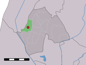
Eenigenburg — Dutch town locator maps mun town caption = The village (dark red) and the statistical district (light green) of Eenigenburg in the municipality of Harenkarspel.Eenigenburg (West Frisian: Einigeborgt ) (coord|52|45|N|4|44|E|type:city(180)) is a… … Wikipedia
Holiday home Merci Eenigenburg — (Eenigenburg,Нидерланды) Категория отеля: 4 звездочный отель Адрес: 1 … Каталог отелей
Harenkarspel — Infobox Settlement official name = Harenkarspel mapsize = 280px flag size = 150x75px image shield = Harenkarspel wapen.png shield size = 150x75px subdivision type = Country subdivision name = Netherlands subdivision type1 = Province subdivision… … Wikipedia
List of places in the Netherlands — This is an alphabetical list of places (cities, towns, villages) in the Netherlands. Lists per province can be found at:* List of towns in Groningen * List of towns in Friesland * List of towns in Drente * List of towns in Overijssel * List of… … Wikipedia
Harenkarspel — Gemeinde Harenkarspel Flagge Wappen Provinz Nordholland Bü … Deutsch Wikipedia
't Rijpje — 52°45′7″N 4°44′51″E / 52.75194, 4.7475 … Wikipédia en Français
Dirkshorn — 52° 45′ 00″ N 4° 47′ 00″ E / 52.75, 4.78333 … Wikipédia en Français
Groenveld — 52° 46′ 00″ N 4° 47′ 00″ E / 52.7667, 4.78333 … Wikipédia en Français
Harenkarspel — Héraldique … Wikipédia en Français
Kalverdijk — 52° 44′ 00″ N 4° 46′ 00″ E / 52.7333, 4.76667 … Wikipédia en Français
 Pays-Bas