Council Bluffs (Iowa)
- Council Bluffs (Iowa)
-
Council Bluffs
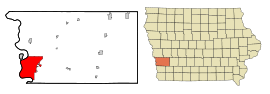
Council Bluffs est une ville américaine, siège du comté de Pottawattamie dans l'ouest de l'Iowa. La population de la ville était en 2006 de 60 271 habitants. La ville est située sur la rive gauche du Missouri, en face d'Omaha.
Histoire
La ville doit son nom à la rencontre de l'expédition Lewis et Clark avec la tribu Oto qui eut lieu près de la ville. Le site de la ville fut d'abord occupé dans les années 1830 par des Amérindiens de la tribu Potawatomi qui furent chassés de la région de Chicago. Pierre-Jean De Smet fut missionnaire un temps parmi ces Amérindiens. Le Fort Croghan fut construit pour contrôler la région.
En 1848, la ville devint Kanesville, du nom de Thomas L. Kane et fut un des points de départ majeurs pour l'exode des Mormons vers l'Utah. Après leur départ, la ville, renommée Council Bluffs, est restée un nœud de transport important. L'interstate 80 et l'interstate 29 traversent la ville.
Personnalités liées à la ville
- John S. McCain, Jr., amiral de l'US Navy, est né dans cette ville ;
- Ernest B. Schoedsack, réalisateur, directeur de la photographie, producteur, monteur, acteur et scénariste, est né à Council Bluffs ;
- Arthur Ward Lindsey, entomologiste, est né à Council Bluffs ;
- Art Farmer, trompettiste de jazz, est né à Council Bluffs ;
- Samuel Ryan Curtis, général de l'US Army, est décédé à Council Bluffs.
Liens externes
 Portail des États-Unis
Catégories : Ville de l'Iowa | Comté de Pottawattamie | Siège de comté de l'Iowa
Wikimedia Foundation.
2010.
Contenu soumis à la licence CC-BY-SA. Source : Article Council Bluffs (Iowa) de Wikipédia en français (auteurs)
Regardez d'autres dictionnaires:
Council Bluffs, Iowa — Historical: Kanesville, Iowa City … Wikipedia
Saint Albert High School (Council Bluffs, Iowa) — Saint Albert High School is a private, Roman Catholic high school in Council Bluffs, Iowa. It is located in the Roman Catholic Diocese of Des Moines.BackgroundSaint Albert was dedicated on June 7, 1964. It replaced Saint Francis, Mount Loretto,… … Wikipedia
Council Bluffs — Der historische Distrikt Haymarket Lage in Iowa … Deutsch Wikipedia
Council Bluffs Express — Founded 2004 Arena Mid America Center Based in Council Bluffs, Iowa Colors … Wikipedia
Council Bluffs Municipal Airport — IATA: CBF – ICAO: KCBF – FAA LID: CBF Summary Airport type Public Operator Council Bluffs Airport Author … Wikipedia
Council Bluffs Railway — The Council Bluffs Railway (reporting mark CBGR) was a shortline Class III railroad that handled freight switching operations in Council Bluffs, Iowa. It operated from May 1991 until July 2006, when it was sold to the Iowa Interstate Railroad.… … Wikipedia
Council Bluffs and Ottumwa Railway — The Council Bluffs and Ottumwa Railway (reporting mark CBOA) was a shortline Class III railroad that handled freight switching operations in Council Bluffs, Iowa. It operated from August 1989 until May 1991, when it was sold to the Council Bluffs … Wikipedia
Council Bluffs Community School District — The Council Bluffs Community School District is a public school district headquartered in the city of Council Bluffs, Iowa, United States. The district serves most of the city of Council Bluffs and the cities of Carter Lake and Crescent. Contents … Wikipedia
Council Bluffs Public Library — The Council Bluffs Public Library serves the residents of Council Bluffs, Iowa, USA along with unincorporated and rural areas of Pottawattamie County.[1] Several cities also contract with the library to provide services. The library is located on … Wikipedia
Council Bluffs — Council Bluffs, IA U.S. city in Iowa Population (2000): 58268 Housing Units (2000): 24340 Land area (2000): 37.383513 sq. miles (96.822851 sq. km) Water area (2000): 2.263147 sq. miles (5.861524 sq. km) Total area (2000): 39.646660 sq. miles (102 … StarDict's U.S. Gazetteer Places
 États-Unis
 Iowa
Iowa