Clarke Island
- Clarke Island
-
Archipel Furneaux
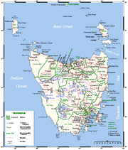
Carte de Tasmanie avec l'archipel Furneaux en haut à droite
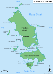
40°0′43″S 148°7′41″E / -40.01194, 148.12806 L'archipel Furneaux (en anglais: The Furneaux Group) est un ensemble de 52 îles tasmaniennes situées[1] à l'extrémité est du détroit de Bass entre la Tasmanie au sud et l'état de Victoria au nord, en Australie. Ces îles formaient une chaine de montagne dans la plaine qui reliait la Tasmanie au continent australien à l'époque glaciaire il y a entre 12 000 et 18 000 ans. Elles doivent leur nom à l'explorateur anglais Tobias Furneaux qui visita la région en 1773.
L'archipel bénéficie d'un climat tempéré doux avec des précipitations de 600 à 800 mm. Les vents peuvent être violents.
L'archipel compte environ 900 habitants.
La plus grande des îles est Flinders Island.
Plus au sud, il y a aussi Cape Barren Island et, encore plus au sud, Clarke Island qui sont, avec Flinders Island, les seules îles habitées en permanence de l'archipel. Elles font partie des Flinders Local government Area (voir zone d'administration locale).
Liens externes
- [1]site officiel de l'archipel
- [2] guide touristique de Flinders Island
Notes et références
 Portail du monde maritime
 Portail de l’Australie
Catégories : Archipel de l'océan Indien | Archipel d'Australie | Géographie de la Tasmanie
Wikimedia Foundation.
2010.
Contenu soumis à la licence CC-BY-SA. Source : Article Clarke Island de Wikipédia en français (auteurs)
Regardez d'autres dictionnaires:
Clarke Island — may be a reference to: Clarke Island (Tasmania), in the Furneaux Group between Victoria and Tasmania, Australia Clark Island (New South Wales), in Sydney Harbour, Australia (sometimes spelt Clarke ) This disambiguation page lists articles about… … Wikipedia
Clarke Island — Vorlage:Infobox Insel/Wartung/Höhe fehlt Clarke Island Satellitenaufnahme … Deutsch Wikipedia
Clarke Island (Tasmania) — Clarke Island Lying below Flinders Island (the large land mass at the top of the image) and Cape Barren Island (the centre large island) is Clarke Island, roughly a quarter of the size of Cape Barren Island. The large land mass at the bottom left … Wikipedia
Clarke Island — /klak ˈaɪlənd/ (say klahk uyluhnd) noun an island off the north eastern coast of Tasmania; a member of the Furneaux Group …
Clarke — bezeichnet einen englischen Familiennamen, siehe Clarke (Familienname) einen Asteroid des Hauptgürtels, siehe (4923) Clarke den Codenamen eines Prozessors, siehe HP Saturn Clarke ist der Name folgender Orte: Château Clarke, ein französisches… … Deutsch Wikipedia
Clarke — Family name A scribe or clerk, the occupation from which the name derives Meaning Clerk, scribe, secretary … Wikipedia
Clarke Street Meeting House — U.S. National Register of Historic Places … Wikipedia
Clarke Gayford — Born Clarke Timothy Gayford 24 October [year missing] Gisborne, New Zealand Occupation Television presenter former Radio DJ Clarke Timothy Gayford was born on 24 October in Gisborne … Wikipedia
Clarke Sound — Coordinates 68°35′N 074°30′W / … Wikipedia
Clarke House — may refer to: Clarke Harrell Burson House, Van Buren, AR, listed on the NRHP in Arkansas Clarke Estate, Santa Fe Springs, CA, listed on the NRHP in California William Clarke Estate, Orange Park, FL, listed on the NRHP in Florida Clarkesville… … Wikipedia
 L'archipel Furneaux

