Citronelle (Alabama)
- Citronelle (Alabama)
-
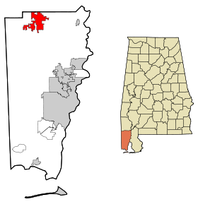
Citronelle est une ville située dans l’État américain de l’Alabama, dans le comté de Mobile. Lors du recensement de 2000, sa population s’élevait à 3 659 habitants.
Le nom de la ville vient du nom de la région nommé ainsi au XVIIIe siècle car beaucoup de citronnelles y poussent. Elle fut colonisée en 1811 et la ville fut fondée en 1892. La région possède aussi de nombreuses autres plantes médicinales et des eaux minérales ce qui avec son climat et ses eaux chaudes, en fit une destination touristiques et vit la construction de nombreux hôtels.
Le 4 mai 1865, la dernière force confédérée d'importance commandée par le Général Richard Taylor se rendit sous le Surrender Oak. Cet évènement est rejoué chaque année à Citronelle mais le chêne a lui été déraciné lors d'un ouragan en 1902.
En 1952, du pétrole fut découvert accidentellement et Citronelle est connu aujourd'hui comme la "capitale pétrolière" de l'Alabama.
Liens externes
Wikimedia Foundation.
2010.
Contenu soumis à la licence CC-BY-SA. Source : Article Citronelle (Alabama) de Wikipédia en français (auteurs)
Regardez d'autres dictionnaires:
Citronelle, Alabama — Citronelle City … Wikipedia
Citronelle (Alabama) — Citronelle Ciudad de los Estados Unidos … Wikipedia Español
Citronelle Railroad Historic District — U.S. National Register of Historic Places U.S. Historic district … Wikipedia
Alabama locations by per capita income — Alabama has the thirty eighth highest per capita income in the United States of America, at $18,189 (2000). Its personal per capita income is $26,338 (2003), the fortieth highest in the country. Its median household income is $34,135 (2000),… … Wikipedia
Citronelle — Citronelle, AL U.S. city in Alabama Population (2000): 3659 Housing Units (2000): 1441 Land area (2000): 24.415665 sq. miles (63.236280 sq. km) Water area (2000): 0.254838 sq. miles (0.660027 sq. km) Total area (2000): 24.670503 sq. miles… … StarDict's U.S. Gazetteer Places
Citronelle, AL — U.S. city in Alabama Population (2000): 3659 Housing Units (2000): 1441 Land area (2000): 24.415665 sq. miles (63.236280 sq. km) Water area (2000): 0.254838 sq. miles (0.660027 sq. km) Total area (2000): 24.670503 sq. miles (63.896307 sq. km)… … StarDict's U.S. Gazetteer Places
Alabama State Route 217 — Infobox road state=AL type=AL route=217 alternate name= length mi=31 length round= length ref= [ [http://colepages.com/routes201225.html#ala217 Highway Route Info Routes 201 225 ] ] established= direction a=South starting terminus= junction=… … Wikipedia
Alabama State Route 17 — Basisdaten Gesamtlänge: 340 mi/547 km Eröffnung: 1 … Deutsch Wikipedia
National Register of Historic Places listings in Mobile County, Alabama — Location of Mobile County in Alabama This is a list of the National Register of Historic Places listings in Mobile County, Alabama. This is intended to be a complete list of the properties and districts on the National Register of Historic Places … Wikipedia
Mount Vernon, Alabama — Town Location … Wikipedia
 États-Unis
 Alabama


