- Chef menteur Highway
-
U.S. Route 90

U.S. Route 90 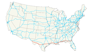
Longueur 2 628 km Extrémité ouest  à Van Horn (Texas)
Intersections  à Houston,
 à la Nouvelle-Orléans,
 à Mobile,
Extrémité est  à Jacksonville Beach
L'U.S. Route 90 (aussi appelée U.S. Highway 90, abrégé en US 90) est une autoroute qui relie Jacksonville, en Floride, à San Antonio, au Texas, le long de la côte atlantique, en passant par la Louisiane, le Mississippi et l'Alabama.
En Louisiane, "U.S. Route 90" prend le surnom de "Chef menteur Highway" en raison de la Passe du Chef menteur qu'elle franchit sur le Pont du Chef menteur.
L'U.S. Route 90 croise l'autoroute Interstate 10 à la hauteur de la Nouvelle-Orléans.
Cet axe routier commence à Jacksonville Beach le long de l'Océan Atlantique à partir de l'autoroute Florida State Road A1A.
Après San Antonio, l'U.S. Route 90 relie l'autoroute Texas State Highway 54 à Van Horn
Voir aussi

Principales routes américaines 1 2 3 4 5 6 7 8 9 10 11 12 13 14 15 16 17 18 19 20 21 22 23 24 25 26 27 28 29 30 31 32 33 34 35 36 37 38 40 41 42 43 44 45 46 48 49 50 51 52 53 54 55 56 57 58 59 60 61 62 63 64 65 66 67 68 69 70 71 72 73 74 75 76 77 78 79 80 81 82 83 84 85 87 89 90 91 92 93 94 95 96 97 98 99 101 163 400 412 425  Portail de la route
 Portail des États-Unis
Catégorie : U.S. Route

Wikimedia Foundation. 2010.