Ceredo
Contenu soumis à la licence CC-BY-SA. Source : Article Ceredo de Wikipédia en français (auteurs)
Regardez d'autres dictionnaires:
Ceredo — Ceredo, WV U.S. city in West Virginia Population (2000): 1675 Housing Units (2000): 888 Land area (2000): 1.343781 sq. miles (3.480377 sq. km) Water area (2000): 0.678723 sq. miles (1.757885 sq. km) Total area (2000): 2.022504 sq. miles (5.238262 … StarDict's U.S. Gazetteer Places
Ceredo, WV — U.S. city in West Virginia Population (2000): 1675 Housing Units (2000): 888 Land area (2000): 1.343781 sq. miles (3.480377 sq. km) Water area (2000): 0.678723 sq. miles (1.757885 sq. km) Total area (2000): 2.022504 sq. miles (5.238262 sq. km)… … StarDict's U.S. Gazetteer Places
Ceredo — Original name in latin Ceredo Name in other language State code US Continent/City America/New York longitude 38.39647 latitude 82.55877 altitude 168 Population 1450 Date 2011 05 14 … Cities with a population over 1000 database
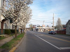
Ceredo, West Virginia — City Looking east along U.S. Route 60 from C Street … Wikipedia
25507 — Ceredo, Wv (Miscellaneous » ZIP Codes) … Abbreviations dictionary
List of cities and towns along the Ohio River — This is a list of cities, towns and communities along the Ohio River in the United States.Alphabetically*Aberdeen, Ohio *Addyston, Ohio *Aliquippa, Pennsylvania *Alton, Indiana *Ambridge, Pennsylvania *Ashland, Kentucky *Athalia, Ohio *Augusta,… … Wikipedia
Mitch Stadium — The Mitch Location 600 Poplar Street Kenova, WV 25530 Broke ground 1955 Opened April … Wikipedia
Dagmar (American actress) — For other uses, see Dagmar (disambiguation). Dagmar Alfred Eisenstaedt photographed Dagmar for the July 16, 1951 issue of Life Born Virginia Ruth Egnor November 29, 1921 … Wikipedia
Huntington, West Virginia — City of Huntington, West Virginia City Huntington s Central Business District as seen from the Robert C. Byrd Bridge at 6th Street … Wikipedia
Kenova, West Virginia — Infobox Settlement official name = Kenova, West Virginia settlement type = City nickname = motto = imagesize = image caption = image mapsize = 250x200px map caption = Location of Kenova, West Virginia mapsize1 = map caption1 = subdivision type =… … Wikipedia

 États-Unis
 Virginie-Occidentale


