8th Avenue Local

8th Avenue Local

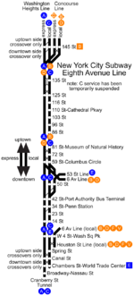
IND Eighth Avenue Line

Le plan de la IND Eight avenue line
Les logos des lignes A,C,E, colorées en bleu marine depuis 1979.

L'IND Eighth Avenue Line fait partie de la Division B du réseau métropolitain de la ville de New York. Cette lignes correspond aux métros A, C et E. Pendant plus de trente ans après sa création en 1932, cette ligne a été nommée Eighth avenue Subway, bien que cela n'ait jamais été son nom officiel. Cette ligne comporte quatre voies sur la plupart de son circuit (une pour les métros express et une pour les métros locaux dans chaque direction), à l'exception de l'extrême nord et de l'extrême sud de cette ligne, où on ne retrouve que deux voies.

La trajet de la ligne A va de l'extrême Nord de Manhattan, au niveau d' Inwood, au sud de Brooklyn, au niveau de la Rockaway Line, en passant par l'aéroport JKF. La ligne C suit le même parcours que la ligne A, mais seulement sur Manhattan, entre Inwood et l'Euclid Avenue, située à la frontière entre le Queens et Manhattan.

La ligne E, rattachée à l'IND Eighth Avenue Line suit quant à elle un parcours totalement différent, elle part de Jamaica 179 St, dans le Queens pour rejoindre le World Trade Center à la pointe Sud de Manhattan. Seule, une courte portion est donc commune aux lignes A,C et E, entre Times Square et le World Trade Center.

Trajet de chaque ligne

Service Parcours desservi
A Express (local en fin de nuit) Parcours entier (Inwood, Rockaway Line)
C Local (ne fonctionne pas en fin de nuit) Du sud de la 168th Street à Euclid Avenue
E Local De la 50th Street au World Trade Center

Voir Métro de New York

  • Portail des transports en commun Portail des transports en commun
Ce document provient de « IND Eighth Avenue Line ».

Wikimedia Foundation. 2010.

Contenu soumis à la licence CC-BY-SA. Source : Article 8th Avenue Local de Wikipédia en français (auteurs)

Игры ⚽ Нужна курсовая?

Regardez d'autres dictionnaires:

  • 8th Avenue Express — IND Eighth Avenue Line Le plan de la IND Eight avenue line Les logos des lignes A …   Wikipédia en Français

  • 8th Street (Manhattan) — Eighth Street is a street in the New York City borough of Manhattan that runs from Sixth Avenue to Third Avenue, and Avenue B to Avenue D; it switches from west to east at Fifth Avenue. Between Third Avenue and Avenue A, the position in the grid… …   Wikipedia

  • 14th Street–Eighth Avenue (New York City Subway) — Infobox NYCS name=14th Street–Eighth Avenue bg color=black accessible=yes service custom=NYCS Eighth south|time=full NYCS Canarsie|time=full borough=Manhattan passengers = 10.198 million pass year = 2006 pass percent = 814th Street–Eighth Avenue… …   Wikipedia

  • Chambers Street–World Trade Center (IND Eighth Avenue Line) — Infobox NYCS name = Chambers Street–World Trade Center accessible = bg color = #11117D line = IND Eighth Avenue Line service = Eighth far south platforms = 2 island platforms tracks = 4 borough = Manhattan transfer station = Park Place transfer… …   Wikipedia

  • Seventh Avenue (IND Culver Line) — Infobox NYCS name = Seventh Avenue bg color = #FF6E1A line = IND Culver Line service = Culver IND south platforms = 2 island platforms tracks = 4 borough = Brooklyn open date = October 7, 1933 north line = IND Culver Line north local station =… …   Wikipedia

  • 163rd Street–Amsterdam Avenue (IND Eighth Avenue Line) — Infobox NYCS name = 163rd Street–Amsterdam Avenue accessible = no bg color = #11117D line = IND Eighth Avenue Line service = Eighth north local platforms = 2 side platforms tracks = 2 borough = Manhattan open date=September 10, 1932New York Times …   Wikipedia

  • IRT Ninth Avenue Line — This article is about the elevated line. For the surface (bus, formerly streetcar) see Ninth and Amsterdam Avenues Line The Ninth Avenue El s suicide curve at 110th Street, in 1896 The IRT Ninth Avenue Line, often called the Ninth Avenue El,[1]… …   Wikipedia

  • IND Eighth Avenue Line — Infobox rail line name=IND Eighth Avenue Line image width=150px caption=The A, C, and E, which use the Eighth Avenue Line through Midtown Manhattan, are colored blue. type=Rapid transit system=New York City Subway start=207th Street end=North of… …   Wikipedia

  • 42nd Street–Port Authority Bus Terminal (IND Eighth Avenue Line) — Infobox NYCS name = 42nd Street–Port Authority Bus Terminal image caption = Southeastern stair accessible = yes acc note = passageway to Times Square–42nd Street is not accessible bg color = #11117D line = IND Eighth Avenue Line service = Eighth… …   Wikipedia

  • 50th Street (IND Eighth Avenue Line) — Infobox NYCS name = 50th Street image size = 275px accessible = southbound acc note = southbound only bg color = #11117D line = IND Eighth Avenue Line line 2 = IND Queens Boulevard Line service=Eighth south local platforms = 4 side platforms (2… …   Wikipedia

Share the article and excerpts

Direct link
Do a right-click on the link above
and select “Copy Link”