Cape Adare
Contenu soumis à la licence CC-BY-SA. Source : Article Cape Adare de Wikipédia en français (auteurs)
Regardez d'autres dictionnaires:
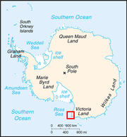
Cape Adare — is the northeastern most peninsula in Victoria Land, East Antarctica. The cape separates the Ross Sea to the east from the Southern Ocean to the west, and is backed by the high Admiralty Mountains. Cape Adare was an important landing site and… … Wikipedia
Cape Adare — DMS … Deutsch Wikipedia
Adare Peninsula — (coord|71|40|S|170|30|E|) is a high ice covered cove, 40 miles (60 km) long, in the northeast part of Victoria Land, extending south from Cape Adare to Cape Roget. Named by the New Zealand Antarctic Place Names Committee (NZ APC) for Cape Adare … Wikipedia
Adare Saddle — (coord|71|44|S|170|12|E|) is a saddle at about 900 m, situated at the junction of Adare Peninsula and the Admiralty Mountains, and at the junction of Newnes Glacier and Moubray Glacier which fall steeply from it. Named by the New Zealand… … Wikipedia
Adare Seamounts — (coord|70|0|S|171|30|E|) are the seamounts in Balleny Basin named in association with Adare Peninsula and Cape Adare. Name approved 6/88 (ACUF 228) … Wikipedia
Adare Trough — (coord|70|2|S|172|30|E|) is an undersea trough name proposed by Dr. Steven C. Cande, Scripps Institution of Oceanography. Named in association with Adare Peninsula and Cape Adare. Name approved 9/97 (ACUF 272) … Wikipedia
Cape Hallett — is the northern tip of the Hallett Peninsula on the Ross Sea coast of Victoria Land, East Antarctica. A very large Adelie penguin rookery is located at Cape Hallett. Cape Adare is 63 miles (101 km) to the northIn 1956, during Operation Deep… … Wikipedia
Adare — Infobox Irish Place name = Adare gaeilge = Áth Dara crest motto = Oh sweet Adare! oh, lovely vale! Oh, oft retreat of sylvan splendour, Nor summer sun, nor morning gale E er hailed a scene more softly tender map pin coords = left: 80px; top: 50px … Wikipedia
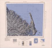
Kap Adare — Topografische Karte von Kap Adare Die beiden von Borchgrev … Deutsch Wikipedia
Southern Cross Expedition — The Southern Cross Expedition, officially known as the British Antarctic Expedition 1898 ndash;1900, was the first British venture of the Heroic Age of Antarctic Exploration, and was the forerunner of the much more celebrated expeditions of… … Wikipedia


