- Bruyelle
-
Bruyelle 


Administration Pays  Belgique
Région  Région wallonne
Communauté Communauté françaiseProvince  Province de Hainaut
Arrondissement Tournai Commune Antoing Géographie Coordonnées Superficie 3,22 km² Population ? hab. (date inconnue) Densité ? hab./km² Autres informations Gentilé Bruyellois(e) Code postal 7641 Zone téléphonique 069 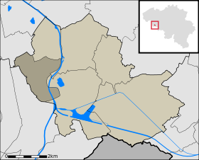
Localisation de Bruyelle au sein d'Antoingmodifier 
Bruyelle (en picard Briyèle, en wallon Briêle) est une section de la ville belge d'Antoing, située en Région wallonne dans la province de Hainaut.
C'était une commune à part entière avant la fusion des communes de 1977.
Toponymie
Étymologie possible : petite bruyère
Anciennes formes : 1187 Bruella
Lieux-dits
Catelet, Couture de Fontenelle, Haute Éloge, Mareteau.
Liens externes
Catégories :- Antoing
- Commune avant fusion de l'arrondissement de Tournai


Wikimedia Foundation. 2010.