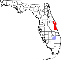
Brevard County
- Brevard County
-
Comté de Brevard
Le comté de Brevard est un comté situé dans l'État de Floride. Sa population était de 476 230 habitants en 2000, elle était estimée à 510 000 en 2005. Le siège du comté est Titusville bien que toute son administration soit présente à Viera. Aucun changement n'a pourtant été effectué depuis 1894 quant à cette situation.
Géographie
Selon le bureau de recensement le comté a une superficie de 4 032 km², dont 1 395 km² sont situés dans l'eau (soit 34,60 % de la surface totale), en majeure partie dans le Indian River Lagoon.
Comtés adjacents
Municipalités
- Cap Canaveral
- Cocoa
- Cocoa Beach
- Indialantic
- Indian Harbour Beach
- Malabar
- Melbourne
- Melbourne Beach
- Melbourne Village
- Palm Bay (autrefois Tillman)
- Palm Shores
- Rockledge
- Satellite Beach
- Titusville
- West Melbourne
Autres
- Barefoot Bay
- Cocoa West
- Grant
- June Park
- John F. Kennedy Space Center
- Merritt Island
- Micco
- Mims
- Port St. John
- Sharpes
- South Patrick Shores
- Suntree
- Valkaria
- Viera
Liens externes
 Portail de la Floride
Catégorie : Comté de Brevard
Wikimedia Foundation.
2010.
Contenu soumis à la licence CC-BY-SA. Source : Article Brevard County de Wikipédia en français (auteurs)
Regardez d'autres dictionnaires:
Brevard County — Courthouse Verwaltung US Bundesstaat: Florida … Deutsch Wikipedia
Brevard County — Admin ASC 2 Code Orig. name Brevard County Country and Admin Code US.FL.009 US … World countries Adminstrative division ASC I-II
Brevard County Social Services — Brevard County tries to provide a number of unique services to help the aged, juveniles, the physically and mentally handicapped, and minorities.ARC Brevard, Inc. provides a spectrum of services for the lifespan of 1200 individuals (and their… … Wikipedia
Brevard County Cocoa Expos — Full name Brevard County Cocoa Expos Nickname(s) Expos Stadium Cocoa Municipal Stadium … Wikipedia
County Road 515 (Brevard County, Florida) — County Road 515 is a north south county highway in Brevard County, Florida adjacent to the Indian River between Sharpes and Rockledge that once served as a part of Dixie Highway and U.S. Route 1. It is a favorite route of bicyclists, and was once … Wikipedia
County Road 503 (Brevard County, Florida) — Brevard County Road 503 (a.k.a Dixon Boulevard) is an 1.5 mile arterial road located entirely within Cocoa, and the zip code, 32922. The road serves central Cocoa, and providing direct access to SR 501 northbound, and State Road 528 westbound to… … Wikipedia
County Road 516 (Brevard County, Florida) — Brevard County Road 516 (locally known as Palm Bay Road)is a former Florida State Road in Brevard County, located entirely in Palm Bay. Between CR 509 and State Road 507, it forms the southern borders of the cities of West Melbourne and Melbourne … Wikipedia
Brevard County, Florida — Infobox U.S. County county = Brevard County state = Florida founded = March 14, 1844 seat = Titusville | area total sq mi =1557 area land sq mi =1018 area water sq mi =539 area percentage = 34.60% census yr = 2000 pop = 476230 density km2 = 181… … Wikipedia
Brevard County Environment — In 1987, Brevard hosted the last member of the Dusky Seaside Sparrow, now extinct. [ [http://www.woodrow.org/teachers/bi/1999/projects/group4/Decker/extinct.html extinct species ] ] There have been only two such avian failures since listing of… … Wikipedia
County Road 507 (Brevard County, Florida) — Infobox road state=FL County type=Brevard route=507 alternate name=Babcock Street maint= length mi=12.45 length round=1 length ref=Florida Department of Transportation, [http://www.dot.state.fl.us/planning/statistics/gis/default.htm FDOT GIS… … Wikipedia

 États-Unis
 Floride
