Bourton-on-the-Water
- Bourton-on-the-Water
-
51° 53′ 11″ N 1° 45′ 32″ W / 51.8864, -1.75877

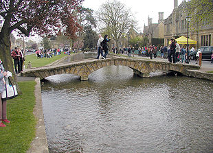
Une passerelle piétonne enjambant la Windrush
Bourton-on-the-Water est un village anglais situé dans le district de Cotswold et le comté de Gloucestershire.
Surnommée la « Venise des Cotswolds » à cause des nombreux ponts traversant la Windrush, rivière coulant à travers le village, Bourton-on-the-Water est une destination touristique comptant de nombreuses attractions.
C'est un des centres touristiques les plus appréciés des Cotswolds, avec un village modèle, « Birdland », et un musée de l'Automobile.
Wikimedia Foundation.
2010.
Contenu soumis à la licence CC-BY-SA. Source : Article Bourton-on-the-Water de Wikipédia en français (auteurs)
Regardez d'autres dictionnaires:
Bourton-on-the-Water — City of Bourton on the Water Bourton on the water Lage in … Deutsch Wikipedia
Bourton-on-the-Water — Infobox UK place official name= Bourton on the Water country= England region= South West England population= os grid reference= SP167209 latitude= 51.88641 longitude= 1.75877 post town= BOURTON ON THE WATER postcode area= GL postcode district=… … Wikipedia
Bourton on the Water — Original name in latin Bourton on the Water Name in other language Bourton on the Water State code GB Continent/City Europe/London longitude 51.86667 latitude 1.75 altitude 131 Population 3162 Date 2012 02 28 … Cities with a population over 1000 database
Bourton-on-the-Water Railway — Die Bourton on the Water Railway war eine Eisenbahngesellschaft in Gloucestershire in England. Die Gesellschaft erhielt am 14. Juni 1860 das Recht zum Bau einer Bahnstrecke von Chipping Northern Junction in der Nähe von Kingham an der Strecke der … Deutsch Wikipedia
Bourton — is the name of more than one place in England: * Bourton, Buckinghamshire * Bourton, Dorset * Bourton, North Somerset * Bourton, Cherwell, Oxfordshire * Bourton, Vale of White Horse, Oxfordshire * Bourton, Shropshire * Bourton on Dunsmore,… … Wikipedia
The Cotswolds (UK Parliament constituency) — Coordinates: 51°45′22″N 1°46′08″W / 51.756°N 1.769°W / 51.756; 1.769 … Wikipedia
Bourton-on-Dunsmore — infobox UK place country = England static static image caption= latitude= 52.32 longitude= 01.37 civil parish= Bourton and Draycote official name =Bourton on Dunsmore population = shire district= Rugby shire county= Warwickshire region= West… … Wikipedia
Long-distance footpaths in the United Kingdom — The following long distance footpaths can be found in the United Kingdom:England and Wales: National TrailsNational Trails are distinguished by being maintained by the National Trails organization [http://www.nationaltrail.co.uk/] . As of|April… … Wikipedia
Meet the Ancestors — BBC Book Cover Genre Documentary Presented by Julian Richards Country of origin … Wikipedia
Telephone numbers in the United Kingdom — +44 redirects here. For the band, see +44 (band). United Kingdom telephone numbers Location of United Kingdom (dark green) Location Country United Kingdom Continent … Wikipedia

