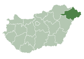
Zavidfalva
- Zavidfalva
-
Zavidfalva est un village et une commune du comitat de Szabolcs-Szatmár-Bereg en Hongrie.
Géographie
Cette section est vide, insuffisamment détaillée ou incomplète.
Votre aide est la bienvenue !
Histoire
Cette section est vide, insuffisamment détaillée ou incomplète.
Votre aide est la bienvenue !
Catégorie :
- Ville et village du comitat de Szabolcs-Szatmár-Bereg
Wikimedia Foundation.
2010.
Contenu soumis à la licence CC-BY-SA. Source : Article Zavidfalva de Wikipédia en français (auteurs)
Regardez d'autres dictionnaires:
Nyíregyháza — City center … Wikipedia
Szabolcs-Szatmár-Bereg County — Infobox Hungarian county name =Szabolcs Szatmár Bereg region =Northern Great Plain seat = Nyíregyháza area = 5936 population = 572,423 density = 96 cities = 228Szabolcs Szatmár Bereg is an administrative county (Hungarian: megye ) in north… … Wikipedia
Máriapócs — Country Hungary County Szabolcs Szatmár Bereg Area Total 22.09 km2 (8 … Wikipedia
Nagykálló — Country Hungary County Szabolcs Szatmár Bereg Area – Total 68.55 km2 (26 … Wikipedia
Nyírtass — Country Hungary County Szabolcs Szatmár Bereg Area Total 37.95 km2 (14 … Wikipedia
Baktalórántháza — Market Town Aerial photograph: Baktalórántháza Palace … Wikipedia
Csenger — Country Hungary County Szabolcs Szatmár Bereg Area Total 36.16 km2 (14&# … Wikipedia
Demecser — Country Hungary County Szabolcs Szatmár Bereg Area – Total 36.99 km2 (14 … Wikipedia
Dombrád — Country Hungary County Szabolcs Szatmár Bereg Area – Total 51.84 km2 (20&# … Wikipedia
Mátészalka — Aerial view … Wikipedia

 Hongrie

