Youngstown (New York)

Youngstown (New York)
Page d'aide sur l'homonymie Pour les articles homonymes, voir Youngstown.

43° 08′ 44″ N 79° 01′ 24″ W / 43.145689, -79.023367

Youngstown
Administration
Pays Drapeau des États-Unis États-Unis
État Drapeau de l'État de New York New York
Comté Niagara
Type de localité City
Maire Neil Riordan
Site web Consulter
Historique
Fondation 1796
Démographie
Population (2010) 1 957 hab.
Densité 544 hab./km²
Géographie
Coordonnées 43° 08′ 44″ Nord
       79° 01′ 24″ Ouest
/ 43.145689, -79.023367
Superficie totale 3,6 km2
· dont terre 3,0 km2 (83,33 %)
· dont eau 0,6 km2 (16,67 %)
Fuseau horaire EST (UTC-5)
Voir la carte administrative
City locator 14.svg
Voir la carte topographique
City locator 14.svg

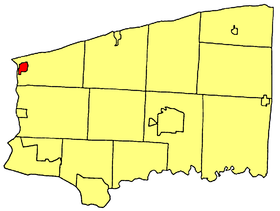
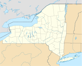
Youngstown est une ville située dans l'ouest de l'État de New York,

Youngstown est sur le côté ouest de New York en face du Canada, et nord de la ville de Niagara Falls.

Sommaire

Histoire

Le début du village était sous la protection du Fort Niagara. Le village fut détruit par les Britanniques en 1813 durant la Guerre de 1812. Le village fut incorporé en 1854, nommé après John Young[1].

Youngstown est village historique localisé sur le côté nordouest où la rivière Niagara coule dans le lac Ontario. Dans un endroit connu par les amérindiens pendant des centaines d'années, l'explorateur La Salle laissa sa marque en construisant un petit fort en 1670. Les Français et Canadiens prirent possesion de la région en construisa le Château en 1727 dans le Fort Niagara.

En 1759, les Britanniques prirent possession du fort dans la bataille de La Belle Famille.

Références

Liens Internes

Liens Externes


Wikimedia Foundation. 2010.

Contenu soumis à la licence CC-BY-SA. Source : Article Youngstown (New York) de Wikipédia en français (auteurs)

Игры ⚽ Поможем сделать НИР

Regardez d'autres dictionnaires:

  • Youngstown (New York) — Youngstown …   Deutsch Wikipedia

  • Youngstown, New York — Infobox Settlement official name = Youngstown, New York settlement type = Village nickname = motto = imagesize = image caption = image |pushpin pushpin label position = pushpin map caption =Location within the state of New York pushpin mapsize =… …   Wikipedia

  • Youngstown (Nueva York) — Youngstown Villa de los Estados Unidos …   Wikipedia Español

  • New York locations by per capita income — New York is the sixth richest state in the United States of America, with a per capita income of $40,272.29 (2004). [1] New York counties ranked by per capita income There are sixty two counties located in New York, six of which are in the 100… …   Wikipedia

  • Newstead, New York — Coordinates: 43°00′49″N 78°30′54″W / 43.01361°N 78.515°W / 43.01361; 78.515 …   Wikipedia

  • Lewiston, New York — Infobox Settlement official name = Lewiston, NY settlement type = Town nickname = motto = imagesize = image caption = image |pushpin pushpin label position = pushpin map caption =Location within the state of New York pushpin mapsize = mapsize =… …   Wikipedia

  • New York State Route 18F — This article is about the current alignment of NY 18F. For the former alignment of NY 18F in Cattaraugus County, see New York State Route 18F (1934–1938). NYS Route 18F Map …   Wikipedia

  • New York State Route 18 — NY 18 redirects here. NY 18 may also refer to New York s 18th congressional district. NYS Route 18 …   Wikipedia

  • New York State Route 93 — NYS Route 93 Map of western New York with NY 93 highlighted in red Route information …   Wikipedia

  • New York State Route 18F — Basisdaten Gesamtlänge:  9.80 mi. / 15,77 km Eröffnung:  1 …   Deutsch Wikipedia

Share the article and excerpts

Direct link
Do a right-click on the link above
and select “Copy Link”